IMAGES TAKEN NEAR TO
Field View, CHIPPENHAM, SN15 5LA
Introduction
This page details the photographs taken nearby to Field View, SN15 5LA by members of the Geograph project.
The Geograph project started in 2005 with the aim of publishing, organising and preserving representative images for every square kilometre of Great Britain, Ireland and the Isle of Man.

There are currently over 7.5m images from over14,400 individuals and you can help contribute to the project by visiting https://www.geograph.org.uk
Image Map
Images are licensed for reuse under creativecommons.org/licenses/by-sa/2.0
Notes
- Clicking on the map will re-center to the selected point.
- The higher the marker number, the further away the image location is from the centre of the postcode.
Image Listing (15 Images Found)
Images are licensed for reuse under creativecommons.org/licenses/by-sa/2.0
Image
Details
Distance
1
Changing names, changing surroundings
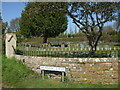
Meadow Lane is now a track beside the cemetery that turns south and stops shortly thereafter. However, in the past it was Mill Lane, running up towards the river and the old King's Mead mill, but was cut it two when the G.W.R. railway carved its way across the countryside in the early 1900s. The cemetery was created about the same time, and the present Mill Lane is the other side of the tracks.
Image: © Neil Owen
Taken: 22 Apr 2021
0.16 miles
2
Allotments beside the cemetery
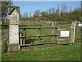
Just south of Little Somerford are allotments between the railway embankment and a cemetery - with this entrance to the former. Upon the stone pillar is a benchmark - see Image] for a closer look.
Image: © Neil Owen
Taken: 22 Apr 2021
0.17 miles
3
Benchmark on the cemetery boundary
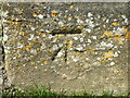
A cutmark of post-war age on the stone pillar marking the boundary of the cemetery and the allotments. See https://www.bench-marks.org.uk/bm147184 for the entry in the Benchmark Database and Image] for a wider view.
Image: © Neil Owen
Taken: 22 Apr 2021
0.17 miles
4
Cemetery - Little Somerford
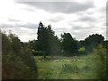
A glimpse of the new cemetery at Little Somerford, dating from 1892.
Image: © Alan Hughes
Taken: 11 Aug 2017
0.18 miles
5
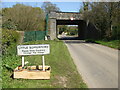
Approaching Little Somerford
The southern road and railway, with a little floral decoration. It's early Spring and the buds are still forming.
Image: © Neil Owen
Taken: 22 Apr 2021
0.18 miles
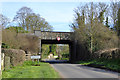
6
Railway bridge over the approach to Little Somerford
Image: © Sarah Charlesworth
Taken: 30 Mar 2010
0.18 miles
7
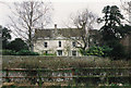
The Mount House
Former home of Mr and Mrs Phillips and their son, Captain Mark Phillips.
Image: © Roger Cornfoot
Taken: Unknown
0.20 miles
8
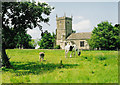
Great Somerford church
Animals graze in the sunshine, in front of the Church of St Peter and St Paul.
Image: © Roger Cornfoot
Taken: Unknown
0.20 miles
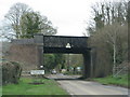
9
Railway bridge, Little Somerford
The South Wales and Bristol Direct line crosses. There was formerly a station off to the right, but no longer, although the line is very much open.
Image: © Robin Webster
Taken: 25 Mar 2017
0.20 miles
10
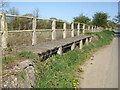
Wooden footbridge on Park Lane
A short section of elevation along the road between the two Somerfords.
Image: © Neil Owen
Taken: 22 Apr 2021
0.21 miles