IMAGES TAKEN NEAR TO
Seagry Heath, CHIPPENHAM, SN15 5EN
Introduction
This page details the photographs taken nearby to Seagry Heath, SN15 5EN by members of the Geograph project.
The Geograph project started in 2005 with the aim of publishing, organising and preserving representative images for every square kilometre of Great Britain, Ireland and the Isle of Man.

There are currently over 7.5m images from over14,400 individuals and you can help contribute to the project by visiting https://www.geograph.org.uk
Image Map
Images are licensed for reuse under creativecommons.org/licenses/by-sa/2.0
Notes
- Clicking on the map will re-center to the selected point.
- The higher the marker number, the further away the image location is from the centre of the postcode.
Image Listing (3 Images Found)
Images are licensed for reuse under creativecommons.org/licenses/by-sa/2.0
Image
Details
Distance
1
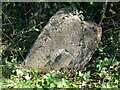
Mis-aligned milestone on the Dauntsey Road
This poor milestone is not only missing the important details, but has also been given a bit of a nudge along the way. It would have said 'Sutton Benger 2' originally but then changed to say 'Malmesbury 5, Sutton Benger 2' in the early 1900s. By the 1920s it now read 'Malmesbury 5, Chippenham 6'. Today it is sadly mute.
See Image] for the top of the toppled stone for a rivet benchmark.
Image: © Neil Owen
Taken: 22 Apr 2021
0.17 miles
2
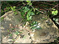
The top of a toppling milestone
This milestone has been knocked about and is leaning at a pronounced angle now. The top surface bears a rivet benchmark (the grey, circular object at the right of the stonework). See https://www.bench-marks.org.uk/bm147193 for the entry in the Benchmark Database and Image] for a wider view.
Image: © Neil Owen
Taken: 22 Apr 2021
0.17 miles
3
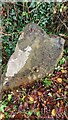
Old Milestone, Great Somerford
On the Eastern side of the road near Seagry Heath. In the parish of Great Somerford. Erected by the Draycot or Upper District Turnpike Trust.
Rivet Benchmark on top representing 63.3 m ASL.
Inscription (was): Malmesbury 5 / Sutton Benger 2
Milestone Society ID: WI_MYSU05
Image: © Tom Blanden
Taken: 23 Nov 2022
0.17 miles