IMAGES TAKEN NEAR TO
East End, CHIPPENHAM, SN15 5EE
Introduction
This page details the photographs taken nearby to East End, SN15 5EE by members of the Geograph project.
The Geograph project started in 2005 with the aim of publishing, organising and preserving representative images for every square kilometre of Great Britain, Ireland and the Isle of Man.

There are currently over 7.5m images from over14,400 individuals and you can help contribute to the project by visiting https://www.geograph.org.uk
Image Map
Images are licensed for reuse under creativecommons.org/licenses/by-sa/2.0
Notes
- Clicking on the map will re-center to the selected point.
- The higher the marker number, the further away the image location is from the centre of the postcode.
Image Listing (5 Images Found)
Images are licensed for reuse under creativecommons.org/licenses/by-sa/2.0
Image
Details
Distance
1
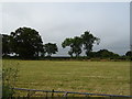
Cut silage field, Callow Hill
Off the B4042.
Image: © JThomas
Taken: 14 Jul 2019
0.11 miles
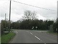
3
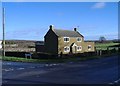
Crossroads at Callow Hill
A small cottage stands at this junction on the B4042. This spot is a notorious accident blackspot, with many fatalities here in recent times.
Image: © Roger Cornfoot
Taken: 10 Jan 2007
0.20 miles
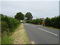
4
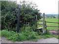
Stile, Callow Hill
The stile gives walkers access to the footpath towards the B4042.
Image: © Maigheach-gheal
Taken: 27 Aug 2010
0.22 miles