IMAGES TAKEN NEAR TO
Fritterswell, CHIPPENHAM, SN15 5DU
Introduction
This page details the photographs taken nearby to Fritterswell, SN15 5DU by members of the Geograph project.
The Geograph project started in 2005 with the aim of publishing, organising and preserving representative images for every square kilometre of Great Britain, Ireland and the Isle of Man.

There are currently over 7.5m images from over14,400 individuals and you can help contribute to the project by visiting https://www.geograph.org.uk
Image Map
Images are licensed for reuse under creativecommons.org/licenses/by-sa/2.0
Notes
- Clicking on the map will re-center to the selected point.
- The higher the marker number, the further away the image location is from the centre of the postcode.
Image Listing (10 Images Found)
Images are licensed for reuse under creativecommons.org/licenses/by-sa/2.0
Image
Details
Distance
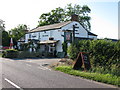
4
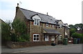
The Suffolk Arms, Brinkworth
On the main road between Swindon and Malmesbury. One of two pubs in what is claimed to be the longest village in England.
Image: © Roger Cornfoot
Taken: 10 Jan 2007
0.13 miles
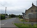
5
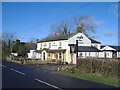
The Suffolk Arms, a summer view
Previously submitted as http://www.geograph.org.uk/photo/308880
Image: © Nick Smith
Taken: 12 Jul 2009
0.13 miles
7
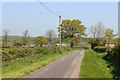
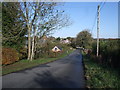
Callow Hill
Minor road towards Bellamys Farm.
Image: © Wayland Smith
Taken: 25 Apr 2020
0.13 miles
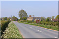
9
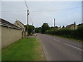
Stoppers Hill, Brinkworth
The view looking down Stoppers Hill, Brinkworth.
Image: © Vieve Forward
Taken: 5 Nov 2012
0.24 miles
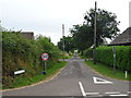
10
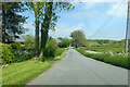
Stoppers Hill
Descending to cross the Woodbridge Brook.
Image: © Robin Webster
Taken: 30 May 2021
0.24 miles