IMAGES TAKEN NEAR TO
Cleverton, CHIPPENHAM, SN15 5BT
Introduction
This page details the photographs taken nearby to SN15 5BT by members of the Geograph project.
The Geograph project started in 2005 with the aim of publishing, organising and preserving representative images for every square kilometre of Great Britain, Ireland and the Isle of Man.

There are currently over 7.5m images from over14,400 individuals and you can help contribute to the project by visiting https://www.geograph.org.uk
Image Map
Images are licensed for reuse under creativecommons.org/licenses/by-sa/2.0
Notes
- Clicking on the map will re-center to the selected point.
- The higher the marker number, the further away the image location is from the centre of the postcode.
Image Listing (5 Images Found)
Images are licensed for reuse under creativecommons.org/licenses/by-sa/2.0
Image
Details
Distance
1
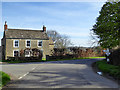
House at junction, Cleverton
The signpost gives Lea, left, Minety round to the right, and Somerfords behind the camera.
Image: © Robin Webster
Taken: 25 Mar 2017
0.01 miles
2
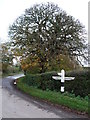
Fingerpost, Cleverton
Fingerpost, with horse chestnut tree in the background.
Image: © Vieve Forward
Taken: 3 Nov 2012
0.02 miles
4
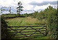
Edge of orchard, Cleverton
A grassy path runs along the west side of a small orchard by the road east of Cleverton.
Image: © Derek Harper
Taken: 19 Jul 2011
0.18 miles
5
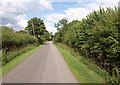
Lane past Manor Farm
The lane ENE of Cleverton, seen from the same spot as Image
Image: © Derek Harper
Taken: 19 Jul 2011
0.21 miles