IMAGES TAKEN NEAR TO
Ash Close, CHIPPENHAM, SN15 4TB
Introduction
This page details the photographs taken nearby to Ash Close, SN15 4TB by members of the Geograph project.
The Geograph project started in 2005 with the aim of publishing, organising and preserving representative images for every square kilometre of Great Britain, Ireland and the Isle of Man.

There are currently over 7.5m images from over14,400 individuals and you can help contribute to the project by visiting https://www.geograph.org.uk
Image Map
Images are licensed for reuse under creativecommons.org/licenses/by-sa/2.0
Notes
- Clicking on the map will re-center to the selected point.
- The higher the marker number, the further away the image location is from the centre of the postcode.
Image Listing (4 Images Found)
Images are licensed for reuse under creativecommons.org/licenses/by-sa/2.0
Image
Details
Distance
1
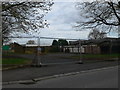
Ripe for re-development?
Boarded and closed off former NAAFI building on Preston Lane.
Image: © Eirian Evans
Taken: 16 Feb 2011
0.16 miles
2
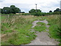
Track, Preston
The track leads to Tockenham Court Farm.
Image: © Maigheach-gheal
Taken: 27 Aug 2010
0.20 miles
3
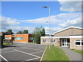
Lyneham Primary School
A modern suite of school buildings off Preston Lane.
Image: © Neil Owen
Taken: 28 May 2022
0.22 miles
4
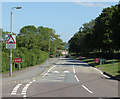
2011 : Preston Lane, Lyneham
The road to Preston, Bushton and Clyffe Pypard.
Image: © Maurice Pullin
Taken: 3 Jun 2011
0.22 miles