IMAGES TAKEN NEAR TO
Grittenham, CHIPPENHAM, SN15 4JS
Introduction
This page details the photographs taken nearby to SN15 4JS by members of the Geograph project.
The Geograph project started in 2005 with the aim of publishing, organising and preserving representative images for every square kilometre of Great Britain, Ireland and the Isle of Man.

There are currently over 7.5m images from over14,400 individuals and you can help contribute to the project by visiting https://www.geograph.org.uk
Image Map
Images are licensed for reuse under creativecommons.org/licenses/by-sa/2.0
Notes
- Clicking on the map will re-center to the selected point.
- The higher the marker number, the further away the image location is from the centre of the postcode.
Image Listing (7 Images Found)
Images are licensed for reuse under creativecommons.org/licenses/by-sa/2.0
Image
Details
Distance
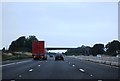
2
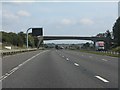
M4 Motorway - farm access overbridge at Grittenham
Image: © J Whatley
Taken: 22 Sep 2010
0.17 miles
3
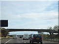
Farm bridge near Grittenham
This small bridge is very similar in appearance to those a short way to the west. (Image] and Image])
Image: © David Smith
Taken: 26 Oct 2011
0.17 miles
5

Wiltshire : Vines Farm
Looking towards a farmhouse and the field.
Image: © Lewis Clarke
Taken: 28 Aug 2018
0.18 miles
6
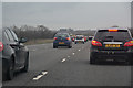
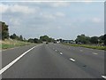
Wiltshire : M4 Motorway
The M4 Motorway between Junction 17 (Stanton St Quinton) and Junction 16 (Spittleborough).
Image: © Lewis Clarke
Taken: 23 Mar 2018
0.21 miles