IMAGES TAKEN NEAR TO
Grittenham, CHIPPENHAM, SN15 4JR
Introduction
This page details the photographs taken nearby to SN15 4JR by members of the Geograph project.
The Geograph project started in 2005 with the aim of publishing, organising and preserving representative images for every square kilometre of Great Britain, Ireland and the Isle of Man.

There are currently over 7.5m images from over14,400 individuals and you can help contribute to the project by visiting https://www.geograph.org.uk
Image Map
Images are licensed for reuse under creativecommons.org/licenses/by-sa/2.0
Notes
- Clicking on the map will re-center to the selected point.
- The higher the marker number, the further away the image location is from the centre of the postcode.
Image Listing (17 Images Found)
Images are licensed for reuse under creativecommons.org/licenses/by-sa/2.0
Image
Details
Distance
2
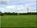
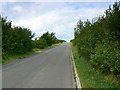
Farmland west of Grittenham
Luker's Farm can be seen in the gap in the hedge.
Image: © Brian Robert Marshall
Taken: 29 Jul 2008
0.13 miles
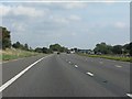
3
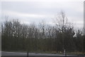
Wiltshire : M4 Motorway
The M4 Motorway between Junction 17 (Stanton St Quinton) and Junction 16 (Spittleborough).
Image: © Lewis Clarke
Taken: 23 Mar 2018
0.15 miles
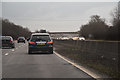
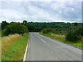
7
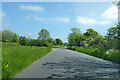
The road to Dauntsey from Grittenham
The road climbs slightly to the point at the northern edge of the square where it starts to pass over the M4.
Image: © Brian Robert Marshall
Taken: 29 Jul 2008
0.19 miles
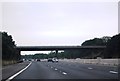
8
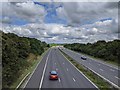
The M4, looking east from a bridge crossing
Image: © Rob Purvis
Taken: 24 Jul 2020
0.19 miles
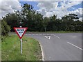
9
The Brinkworth road towards Grittenham
The road is approaching a T junction. The M4 is behind the viewpoint.
Image: © Brian Robert Marshall
Taken: 29 Jul 2008
0.19 miles