IMAGES TAKEN NEAR TO
The Green, CHIPPENHAM, SN15 4HY
Introduction
This page details the photographs taken nearby to The Green, SN15 4HY by members of the Geograph project.
The Geograph project started in 2005 with the aim of publishing, organising and preserving representative images for every square kilometre of Great Britain, Ireland and the Isle of Man.

There are currently over 7.5m images from over14,400 individuals and you can help contribute to the project by visiting https://www.geograph.org.uk
Image Map
Images are licensed for reuse under creativecommons.org/licenses/by-sa/2.0
Notes
- Clicking on the map will re-center to the selected point.
- The higher the marker number, the further away the image location is from the centre of the postcode.
Image Listing (10 Images Found)
Images are licensed for reuse under creativecommons.org/licenses/by-sa/2.0
Image
Details
Distance
1
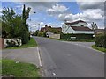
The Green, Dauntsey
The name of the road - an actual green is not obvious.
Image: © Robin Webster
Taken: 30 May 2021
0.06 miles
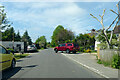
2
The Green, Dauntsey
The name of the road - an actual green is not obvious.
Image: © Robin Webster
Taken: 30 May 2021
0.08 miles
3
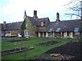
Dauntsey primary school
This old village school sits alongside a row of former almshouses.
Image: © Roger Cornfoot
Taken: 28 Dec 2006
0.10 miles
4
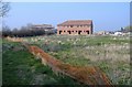
New development, at Dauntsey
A large building site is emerging from what was Great Middle Green Farm.
Image: © Roger Cornfoot
Taken: 27 Mar 2007
0.10 miles
5
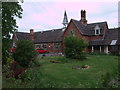
Earl Danby's School, Dauntsey
The Lower School of Earl Danby's Voluntary Controlled Primary School has its origins in 1645, when the Earl of Danby left money in his will for a school and almshouses. In 1864, the new National School was built to accommodate 100 children. When numbers dropped recently, it became federated with what is now the Upper School in Brinkworth.
Image: © Vieve Forward
Taken: 9 Jun 2013
0.11 miles
6
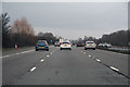
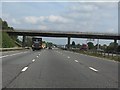
Wiltshire : M4 Motorway
The M4 Motorway between Junction 17 (Stanton St Quinton) and Junction 16 (Spittleborough).
Image: © Lewis Clarke
Taken: 23 Mar 2018
0.16 miles
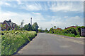
7
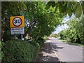
Entering Dauntsey, please drive carefully
Image: © Rob Purvis
Taken: 24 Jul 2020
0.16 miles
8
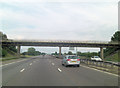
M4 roadbridge - lane from Dauntseys to Swallett Gate crosses
To the north of the motorway this is called Church Lane but to the south it is joined by Sodom Lane. Talk about the wrong side of the tracks!
Image: © Stuart Logan
Taken: 13 Jul 2011
0.23 miles