IMAGES TAKEN NEAR TO
Hercules View, CHIPPENHAM, SN15 4FB
Introduction
This page details the photographs taken nearby to Hercules View, SN15 4FB by members of the Geograph project.
The Geograph project started in 2005 with the aim of publishing, organising and preserving representative images for every square kilometre of Great Britain, Ireland and the Isle of Man.

There are currently over 7.5m images from over14,400 individuals and you can help contribute to the project by visiting https://www.geograph.org.uk
Image Map
Images are licensed for reuse under creativecommons.org/licenses/by-sa/2.0
Notes
- Clicking on the map will re-center to the selected point.
- The higher the marker number, the further away the image location is from the centre of the postcode.
Image Listing (28 Images Found)
Images are licensed for reuse under creativecommons.org/licenses/by-sa/2.0
Image
Details
Distance
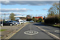
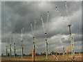
1
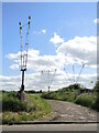
Lights in Greenfield
The old R.A.F. Lyneham airfield is no longer in full military use, having closed about a decade ago. However, the runway lights are still here close to the Chippenham Road.
Image: © Neil Owen
Taken: 28 May 2022
0.05 miles
3
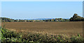
2011 : East over a ploughed field off the B4069
At The Banks.
Landing lights (now redundant) for the nearby Lyneham Airfield line up on the far side of the field. Houses on the edge of Lyneham peer over the hill.
Image: © Maurice Pullin
Taken: 15 Oct 2011
0.08 miles
4
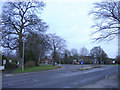
Roundabout at Lyneham
The road from Swindon joins at the left.
Image: © Roger Cornfoot
Taken: 30 Dec 2006
0.09 miles
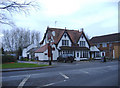
5
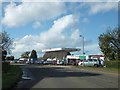
Used car sales on Chippenham Road
The B4069.
Image: © Robin Webster
Taken: 2 Feb 2018
0.09 miles
6
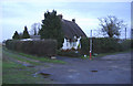
Thatched cottage at Lyneham
Located beneath the flightpath at RAF Lyneham.
Image: © Roger Cornfoot
Taken: 30 Dec 2006
0.09 miles
7
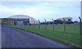
Hangar at RAF Lyneham
Seen from the Bradenstoke village road.
Image: © Roger Cornfoot
Taken: 30 Dec 2006
0.09 miles
9
Landing lights and a cloudy sky, St Michael's Close, Lyneham
The weather had been sunny earlier. Now it's starting to cloud over.
Image: © Brian Robert Marshall
Taken: 2 Mar 2009
0.09 miles
10
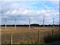
Landing lights, St Michael's Close, Lyneham
These lights illuminate the westerly approach for Runway 25, RAF Lyneham. '25' is an abbreviation for a compass bearing of 250 degrees and indicates the orientation of the runway and the approach needed to land on it.
Image: © Brian Robert Marshall
Taken: 2 Mar 2009
0.09 miles