IMAGES TAKEN NEAR TO
Slessor Road, CHIPPENHAM, SN15 4EA
Introduction
This page details the photographs taken nearby to Slessor Road, SN15 4EA by members of the Geograph project.
The Geograph project started in 2005 with the aim of publishing, organising and preserving representative images for every square kilometre of Great Britain, Ireland and the Isle of Man.

There are currently over 7.5m images from over14,400 individuals and you can help contribute to the project by visiting https://www.geograph.org.uk
Image Map
Images are licensed for reuse under creativecommons.org/licenses/by-sa/2.0
Notes
- Clicking on the map will re-center to the selected point.
- The higher the marker number, the further away the image location is from the centre of the postcode.
Image Listing (8 Images Found)
Images are licensed for reuse under creativecommons.org/licenses/by-sa/2.0
Image
Details
Distance
1
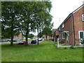
Housing estate, Lyneham
Military housing for RAF Lyneham.
Image: © Vieve Forward
Taken: 17 Jul 2016
0.04 miles
2
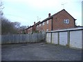
Service houses near RAF Lyneham
Lockup garages at the end of the street.
Image: © Roger Cornfoot
Taken: 15 Feb 2007
0.06 miles
3
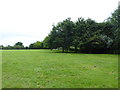
Playing field, Lyneham
Big playing field for the residents of the military housing estate serving RAF Lyneham.
Image: © Vieve Forward
Taken: 17 Jul 2016
0.08 miles
4
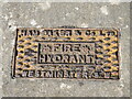
A tasty hydrant
The large housing estate in Lyneham is one built for the military presence that inhabited the village for many years. As part of that post-WWII drive, the utilities were supplied in part by Ham, Baker and Company. They were a metal engineers, founders and water systems manufacturer, started in 1893 in the West Midlands. Their product range expanded to provide many forms of water management hardware, of which this hydrant cover is one.
The company was taken over by Biwater in 1980 and the original site demolished in 2000, but the name carried on as a subsidiary in Stoke on Trent. The Westminster part of the cover refers to a company office address - quite a common practice.
Image: © Neil Owen
Taken: 28 May 2022
0.14 miles
5
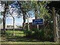
Lyneham Scouts and Guides hut
In the hut beyond the fencing. Note that there are several military buildings (part of the former R.A.F. airfield) in the area and is close by.
Image: © Neil Owen
Taken: 28 May 2022
0.16 miles
6
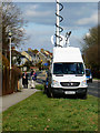
TV crew, A3102, Lyneham
The man in the dark coat is a reporter from the BBC 'Points West' television programme and alongside him is his cameraman. There is more information in the description to this image http://www.geograph.org.uk/photo/1187146
Image: © Brian Robert Marshall
Taken: 2 Mar 2009
0.20 miles
7
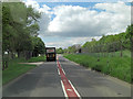
A3102 to the east of Lynham Airfield
Evidence of the RAF Transport Command airfield is the presence of security fencing.
Image: © Stuart Logan
Taken: 16 May 2012
0.20 miles
8
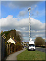
A3102, Lyneham
The main road from Calne to Lyneham and Wootton Bassett is visible at the right. The van with the tall antenna is from BBC 'Points West'. It is probably here because a flight is due in from Afghanistan tomorrow bearing the latest batch of soldiers killed on active service.
Image: © Brian Robert Marshall
Taken: 2 Mar 2009
0.22 miles