IMAGES TAKEN NEAR TO
Christian Malford, CHIPPENHAM, SN15 4DB
Introduction
This page details the photographs taken nearby to SN15 4DB by members of the Geograph project.
The Geograph project started in 2005 with the aim of publishing, organising and preserving representative images for every square kilometre of Great Britain, Ireland and the Isle of Man.

There are currently over 7.5m images from over14,400 individuals and you can help contribute to the project by visiting https://www.geograph.org.uk
Image Map
Images are licensed for reuse under creativecommons.org/licenses/by-sa/2.0
Notes
- Clicking on the map will re-center to the selected point.
- The higher the marker number, the further away the image location is from the centre of the postcode.
Image Listing (9 Images Found)
Images are licensed for reuse under creativecommons.org/licenses/by-sa/2.0
Image
Details
Distance
1

Swallett Lodge
Half-timbered house usually hidden from sight by the trees.
Image: © Eirian Evans
Taken: 16 Feb 2011
0.04 miles
2
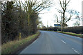
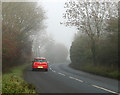
B4069 at 7 miles to Wootton Bassett
Note the milestone on the left. For a close-up and details, see http://www.imagesofengland.org.uk/details/default.aspx?id=316268 .
Image: © Robin Webster
Taken: 2 Feb 2018
0.12 miles
3
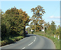
2010 : B4069 passing Swallett Farm
Crossing the north west corner of the grid square as it heads for Lyneham where it ends at the junction with the A3102.
Autumn tints beginning to show.
Image: © Maurice Pullin
Taken: 4 Oct 2010
0.15 miles
5
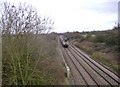
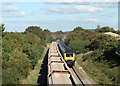
Main line to Paddington
An HST speeds through Dauntsey vale with a train from Bristol to London.
Image: © Roger Cornfoot
Taken: 12 Jan 2007
0.20 miles
6
2010 : Main line between Bristol Temple Meads and Paddington
A First Direct HST heading for Bristol passes a "stone" train heading east.
The goods carries a load of Mendip limestone, probably from quarries at Merehead or Whatley.
Taken from a bridge carrying a minor road from the B4096. The next bridge along carries a footpath.
Note the new barn, not present in Jan 2007 Image
Image: © Maurice Pullin
Taken: 4 Oct 2010
0.21 miles
7
2010 : Parapet on a railway bridge carrying a minor road
Looking north of west toward the B4069.
The parapet is built with engineering bricks much used by the railways during the 19th and 20th centuries.
The house opposite the end of the road is at Upper Town.
The bridge crosses the main Paddington to Bristol railway line.
Image: © Maurice Pullin
Taken: 4 Oct 2010
0.21 miles
8
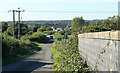
2010 : B4069 north east at the end of Dodford Lane
Dauntsey Lock just over one mile then Lyneham where it joins the A3102.
Image: © Maurice Pullin
Taken: 15 Nov 2010
0.23 miles
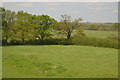
9
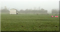
2010 : Field near Lyneham
This image was taken to show the remaining evidence of medieval strip farming, the early moisture on the ground shows up the ridges and furrows.
Farms were much smaller in medieval times and the peasants who worked the land did not own the land they worked on. This belonged to the lord of the manor. In this sense, peasants were simply tenants who worked a strip of land or maybe several strips. Hence why this type of farming was called strip farming.
Paraphrased from: http://www.historylearningsite.co.uk/medieval_farming1.htm
Image: © Maurice Pullin
Taken: 15 Nov 2010
0.24 miles