IMAGES TAKEN NEAR TO
Main Road, CHIPPENHAM, SN15 4BS
Introduction
This page details the photographs taken nearby to Main Road, SN15 4BS by members of the Geograph project.
The Geograph project started in 2005 with the aim of publishing, organising and preserving representative images for every square kilometre of Great Britain, Ireland and the Isle of Man.

There are currently over 7.5m images from over14,400 individuals and you can help contribute to the project by visiting https://www.geograph.org.uk
Image Map
Images are licensed for reuse under creativecommons.org/licenses/by-sa/2.0
Notes
- Clicking on the map will re-center to the selected point.
- The higher the marker number, the further away the image location is from the centre of the postcode.
Image Listing (5 Images Found)
Images are licensed for reuse under creativecommons.org/licenses/by-sa/2.0
Image
Details
Distance
1
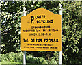
2010 : Porter Recycling
I have a rather pleasant way to recycle porter.
Sign outside a recycling depot on the B4069 east of Christian Malford.
Image: © Maurice Pullin
Taken: 4 Oct 2010
0.10 miles
2
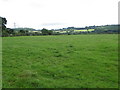
Pasture near Beanhill Farm
There is supposed to be a footpath across this field, but it is not visible on the ground.
Image: © Maigheach-gheal
Taken: 27 Aug 2010
0.13 miles
3
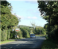
2010 : B4069 near Christian Malford
Heading east and north to Lyneham.
The turning on the right is for Foxham.
Image: © Maurice Pullin
Taken: 4 Oct 2010
0.17 miles
4
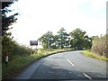
Advance signs for turning to Foxton on B4069
Image: © David Smith
Taken: 18 Oct 2012
0.20 miles