IMAGES TAKEN NEAR TO
Wicks Drive, CHIPPENHAM, SN15 3FS
Introduction
This page details the photographs taken nearby to Wicks Drive, SN15 3FS by members of the Geograph project.
The Geograph project started in 2005 with the aim of publishing, organising and preserving representative images for every square kilometre of Great Britain, Ireland and the Isle of Man.

There are currently over 7.5m images from over14,400 individuals and you can help contribute to the project by visiting https://www.geograph.org.uk
Image Map
Images are licensed for reuse under creativecommons.org/licenses/by-sa/2.0
Notes
- Clicking on the map will re-center to the selected point.
- The higher the marker number, the further away the image location is from the centre of the postcode.
Image Listing (7 Images Found)
Images are licensed for reuse under creativecommons.org/licenses/by-sa/2.0
Image
Details
Distance
1
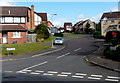
Rumble Dene, Chippenham
Viewed from Webbington Road.
Image: © Jaggery
Taken: 14 Sep 2012
0.13 miles
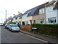
2
Chivers Road, Chippenham
Viewed from Webbington Road. Chivers Road leads to Rowe Mead.
Image: © Jaggery
Taken: 14 Sep 2012
0.13 miles
3
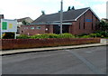
Chippenham Christian Fellowship church, Chippenham
The Elim Pentecostal church is located in Wood Lane in the SE of Chippenham.
Image: © Jaggery
Taken: 14 Sep 2012
0.14 miles
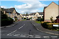
4
Rook Nest Close, Chippenham
Looking west from Blackthorn Mews. Several references show Rooks Nest Close but the name sign on the left shows Rook Nest Close. A sign alongside the hedge on the left points towards Forest Lane.
Image: © Jaggery
Taken: 14 Sep 2012
0.19 miles
5
The Old Lane, Chippenham
Viewed across Lodge Road. The Old Lane pub is part of the Sizzling Pubs group.
Image: © Jaggery
Taken: 14 Sep 2012
0.19 miles
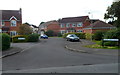
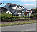
6
Cricketts Lane houses, Chippenham
Viewed from near the Wood Lane junction.
Image: © Jaggery
Taken: 14 Sep 2012
0.20 miles
7
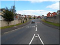
Webbington Road, Chippenham
Viewed from Webbington Roundabout on the A4 Pewsham Way.
Image: © Jaggery
Taken: 14 Sep 2012
0.22 miles