IMAGES TAKEN NEAR TO
London Road, CHIPPENHAM, SN15 3AX
Introduction
This page details the photographs taken nearby to London Road, SN15 3AX by members of the Geograph project.
The Geograph project started in 2005 with the aim of publishing, organising and preserving representative images for every square kilometre of Great Britain, Ireland and the Isle of Man.

There are currently over 7.5m images from over14,400 individuals and you can help contribute to the project by visiting https://www.geograph.org.uk
Image Map
Images are licensed for reuse under creativecommons.org/licenses/by-sa/2.0
Notes
- Clicking on the map will re-center to the selected point.
- The higher the marker number, the further away the image location is from the centre of the postcode.
Image Listing (94 Images Found)
Images are licensed for reuse under creativecommons.org/licenses/by-sa/2.0
Image
Details
Distance
1
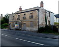
Long derelict building, London Road, Chippenham
Located at the NW end of London Road, near Queens Square.
I didn't see anything here I recognised as a clue to the building's former use.
What is a house, guest house, pub? Why is it derelict?
Image: © Jaggery
Taken: 14 Sep 2012
0.02 miles
2
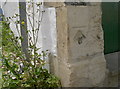
Haven mark
This benchmark is one made in the original nineteenth century surveying of Chippenham. See http://www.bench-marks.org.uk/bm50207 for the entry in the Benchmark Database and Image] for a wider view.
Image: © Neil Owen
Taken: 30 Jun 2014
0.03 miles
3
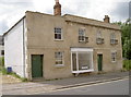
Haven House
This property has stood here amidst the frequent changes and new roads built around it. Having suffered from some neglect it now looks like it has a brighter future - provided someone can come up with the money. It also has an old benchmark - see Image
Image: © Neil Owen
Taken: 30 Jun 2014
0.03 miles
5
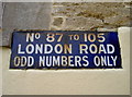
Old enamel
An old and rusty sign, preserved by the more modern rendering and a coat of paint.
Image: © Neil Owen
Taken: 30 Jun 2014
0.04 miles
6
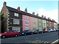
Long row of colourful houses, London Road, Chippenham
Viewed from near the corner of Phoenix Close, opposite April Cottage. The row extends for about 50 metres.
Image: © Jaggery
Taken: 14 Sep 2012
0.04 miles
7
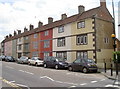
Along London Road
These are Victoria Buildings, a rather colourful crowd. On the nearest corner are an enamel sign (see Image]) and a benchmark (see Image]).
Image: © Neil Owen
Taken: 30 Jun 2014
0.05 miles
8
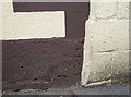
London Road benchmark
A cutmark, as listed in the Benchmark Database: http://www.bench-marks.org.uk/bm50209 , on the corner of Victoria Buildings. See Image] for a wider view.
Image: © Neil Owen
Taken: 30 Jun 2014
0.05 miles
9
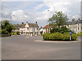
The new roundabout
This particular piece of highway engineering was opened in 1988 and is part of the Inner Relief Road for the town. The new road to the left is named Avenue La Fleche, after the French town which was twinned with Chippenham in 1983. See Image] for a commemorative stone.
Image: © Neil Owen
Taken: 30 Jun 2014
0.05 miles
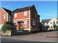
10
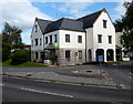
Jobcentre Plus, Chippenham
Viewed across Avenue La Fleche.
Chippenham is twinned with La Flèche in France (and Friedberg in Germany).
Image: © Jaggery
Taken: 14 Sep 2012
0.05 miles