IMAGES TAKEN NEAR TO
Lacock Road, CHIPPENHAM, SN15 2NT
Introduction
This page details the photographs taken nearby to Lacock Road, SN15 2NT by members of the Geograph project.
The Geograph project started in 2005 with the aim of publishing, organising and preserving representative images for every square kilometre of Great Britain, Ireland and the Isle of Man.

There are currently over 7.5m images from over14,400 individuals and you can help contribute to the project by visiting https://www.geograph.org.uk
Image Map
Images are licensed for reuse under creativecommons.org/licenses/by-sa/2.0
Notes
- Clicking on the map will re-center to the selected point.
- The higher the marker number, the further away the image location is from the centre of the postcode.
Image Listing (9 Images Found)
Images are licensed for reuse under creativecommons.org/licenses/by-sa/2.0
Image
Details
Distance
1
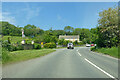
B4528 by Holywell House
Towards Chippenham.
Image: © Robin Webster
Taken: 30 May 2021
0.02 miles
2
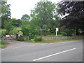
Entrance to Holywell House
A view looking across the old A350 road (now possibly the B4528 since the opening of the A350 Chippenham bypass) towards the entrance to Holywell House.
Image: © Phil Williams
Taken: 27 Jun 2006
0.05 miles
3
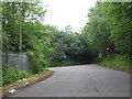
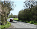
2011 : A350 looking north toward Chippenham
This is the original A350, the Chippenham bypass, about half a mile west, is also called the A350.
Image: © Maurice Pullin
Taken: 8 Apr 2011
0.08 miles
4
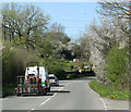
Salterford Lane
A view looking south along Saltersford Lane towards the traffic lights controlling the traffic through the single lane section of road under the high arch railway bridge on the left of the image.
Image: © Phil Williams
Taken: 27 Jun 2006
0.09 miles
5
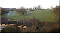
2011 : Dead muckspreader near Chippenham
This muckspreader is no more, it has hurled its last, gone to the great muckheap in the sky etc.
Looking east near Patterdown Farm.
Image: © Maurice Pullin
Taken: 8 Apr 2011
0.13 miles
6
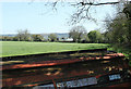
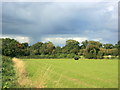
Field south of Chippenham
The line of trees is a vestige of an old field boundary. Looking over Queensbridge Cottages from the railway line south of Chippenham as it crosses a tributary valley of the Avon on an embankment.
Image: © Derek Harper
Taken: 23 Nov 2012
0.18 miles
7
2011 : A350 heading south toward Lacock and Melksham
Is joined by the Chippenham bypass about half a mile further on which is also called the A350.
Image: © Maurice Pullin
Taken: 8 Apr 2011
0.19 miles
9
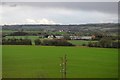
2008 : Farmland near Chippenham
The centre of Chippenham is 3Km north of here, too close for comfort.
Image: © Maurice Pullin
Taken: 2 Oct 2008
0.24 miles