IMAGES TAKEN NEAR TO
Bowood Road, SWINDON, SN1 4LP
Introduction
This page details the photographs taken nearby to Bowood Road, SN1 4LP by members of the Geograph project.
The Geograph project started in 2005 with the aim of publishing, organising and preserving representative images for every square kilometre of Great Britain, Ireland and the Isle of Man.

There are currently over 7.5m images from over14,400 individuals and you can help contribute to the project by visiting https://www.geograph.org.uk
Image Map
Images are licensed for reuse under creativecommons.org/licenses/by-sa/2.0
Notes
- Clicking on the map will re-center to the selected point.
- The higher the marker number, the further away the image location is from the centre of the postcode.
Image Listing (82 Images Found)
Images are licensed for reuse under creativecommons.org/licenses/by-sa/2.0
Image
Details
Distance
1
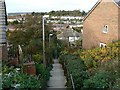
Footpath from Okus Road to Kingshill Road, Swindon
The path, which takes the form of shallow concrete steps, provides a shortcut from Okus Road, in Old Town, to the newer part of Swindon, once referred to as New Town. The camera is pointing downwards and this causes interesting parallax effects.
Image: © Brian Robert Marshall
Taken: 29 Oct 2007
0.06 miles
2
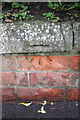
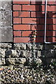
Benchmark on roadside wall of #61 Kingshill Road
Ordnance Survey cut mark benchmark described on the Bench Mark Database at http://www.bench-marks.org.uk/bm40450
Image: © Roger Templeman
Taken: 5 Jan 2012
0.07 miles
3
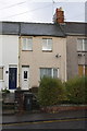
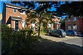
#61 Kingshill Road
There is an OS benchmark Image on the wall in front of the house below the dip in the hedge
Image: © Roger Templeman
Taken: 5 Jan 2012
0.07 miles
4
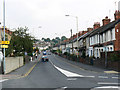
Swindon : Kingshill Road A4289
Looking along Kingshill Road.
Image: © Lewis Clarke
Taken: 14 Jul 2022
0.08 miles
5
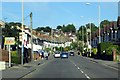
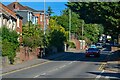
Kingshill Road, Swindon
Kingshill Road was and remains the main route into Old Town from the west. The houses along it are late Victorian or Edwardian. The yellow signs at the left indicate the route for the Wichelstowe development Image
Image: © Brian Robert Marshall
Taken: 19 Sep 2009
0.09 miles
6
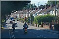
Swindon : Kingshill Road A4289
Looking down the hill.
Image: © Lewis Clarke
Taken: 14 Jul 2022
0.09 miles
7
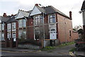
Swindon : Houses
Houses seen from Kingshill Road.
Image: © Lewis Clarke
Taken: 14 Jul 2022
0.10 miles
8
Benchmark on #47 Okus Road
Ordnance Survey cut mark benchmark described on the Bench Mark Database at http://www.bench-marks.org.uk/bm40808
Image: © Roger Templeman
Taken: 5 Jan 2012
0.10 miles
9
#47 Okus Road at junction with Sandy Lane
There is an OS benchmark Image on the side of the nearest house
Image: © Roger Templeman
Taken: 5 Jan 2012
0.10 miles