IMAGES TAKEN NEAR TO
The Mall, SWINDON, SN1 4JE
Introduction
This page details the photographs taken nearby to The Mall, SN1 4JE by members of the Geograph project.
The Geograph project started in 2005 with the aim of publishing, organising and preserving representative images for every square kilometre of Great Britain, Ireland and the Isle of Man.

There are currently over 7.5m images from over14,400 individuals and you can help contribute to the project by visiting https://www.geograph.org.uk
Image Map
Images are licensed for reuse under creativecommons.org/licenses/by-sa/2.0
Notes
- Clicking on the map will re-center to the selected point.
- The higher the marker number, the further away the image location is from the centre of the postcode.
Image Listing (77 Images Found)
Images are licensed for reuse under creativecommons.org/licenses/by-sa/2.0
Image
Details
Distance
1
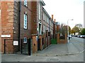
Commonweal School, the Mall, Swindon
The school dates from 1927 and was built originally as a local education authority grammar school. It became a comprehensive in the 1960s and is now a performing arts college. This is a view facing north along the Mall.
Image: © Brian Robert Marshall
Taken: 29 Oct 2007
0.02 miles
2
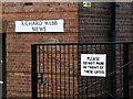
Richard Webb Mews, Commonweal School, Swindon
The mews isn't a row of houses; it appears to be simply the southern end of the school building. I understand the name is that of a late benefactor.
Image: © Brian Robert Marshall
Taken: 29 Oct 2007
0.02 miles
3
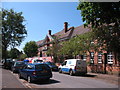
Commonweal School, Swindon
Built in 1927 as the town's first grammar school, it became a comprehensive school in the late sixties and has seen several changes since. Currently undergoing some refurbishment. Seat of learning for at least two regular 'geograph' contributors.
Image: © Gordon Hatton
Taken: 3 Jun 2010
0.04 miles
4
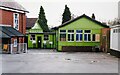
The woodwork room
The wooden buildings at one end of Commonweal School once comprised 2 or 3 classrooms and the woodwork room, which is the gable ended building here. Some 60 years ago [and more] those pupils of the former Grammar School who were considered not good enough for Latin classes [including this contributor] were sent out here to make things out of wood, not all creations being works of art. To the left, at a corner of the main building, were the boys changing rooms and showers, where the water varied wildly between boiling hot and freezing cold.
Image: © Gordon Hatton
Taken: 19 Oct 2002
0.05 miles
5
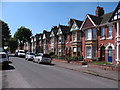
Houses on Mill Lane
South facing houses catching some winter afternoon sunshine.
Image: © Des Blenkinsopp
Taken: 19 Jan 2023
0.08 miles
6
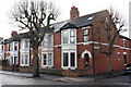
#110 Goddard Avenue at Commonweal Road junction
There is an OS benchmark Image near the junction of the house and its front side wall.
Image: © Roger Templeman
Taken: 5 Jan 2012
0.08 miles
7
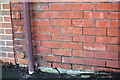
Benchmark on #110 Goddard Avenue
Ordnance Survey cut mark benchmark described on the Bench Mark Database at http://www.bench-marks.org.uk/bm40448
Image: © Roger Templeman
Taken: 5 Jan 2012
0.08 miles
8
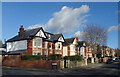
The Mall, Swindon
Terraced houses of the early 20th century at the top of the hill in Swindon. This part of town was seen as more desirable than areas close to the railway works, thus the superior spacious houses and the rather grand street name. If you lived here in the 1920's then you had 'arrived'. One of the houses in the photo was the boyhood home of Justin Hayward, famous rock guitarist and lead singer of the Moody Blues.
Image: © Gordon Hatton
Taken: 3 Jun 2010
0.11 miles
9
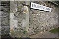
Benchmark on wall at Belmont Crescent junction
Ordnance Survey cut mark benchmark described on the Bench Mark Database at http://www.bench-marks.org.uk/bm40829
Image: © Roger Templeman
Taken: 5 Jan 2012
0.13 miles
10
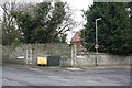
Junction of Belmont Crescent and Westlecot Road
There is an OS benchmark Image on the wall pier left of the Belmont Crescent road name sign.
Image: © Roger Templeman
Taken: 5 Jan 2012
0.13 miles