IMAGES TAKEN NEAR TO
Belmont Crescent, SWINDON, SN1 4EY
Introduction
This page details the photographs taken nearby to Belmont Crescent, SN1 4EY by members of the Geograph project.
The Geograph project started in 2005 with the aim of publishing, organising and preserving representative images for every square kilometre of Great Britain, Ireland and the Isle of Man.

There are currently over 7.5m images from over14,400 individuals and you can help contribute to the project by visiting https://www.geograph.org.uk
Image Map
Images are licensed for reuse under creativecommons.org/licenses/by-sa/2.0
Notes
- Clicking on the map will re-center to the selected point.
- The higher the marker number, the further away the image location is from the centre of the postcode.
Image Listing (38 Images Found)
Images are licensed for reuse under creativecommons.org/licenses/by-sa/2.0
Image
Details
Distance
1
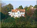
Belmont Crescent, Old Town, Swindon
Belmont Crescent in Old Town, Swindon is an expensive part of the town in which to live. Properties here don't appear on the market that often but when they do prices will be in excess of £500,000.
Image: © Brian Robert Marshall
Taken: 14 Oct 2007
0.01 miles
2
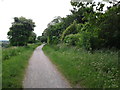
Old railway track cycle path heading west
Image: © Rob Purvis
Taken: 11 Jun 2013
0.05 miles
3
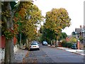
Belmont Crescent, Old Town, Swindon
This is a view facing east along the fairly secluded road of large villas. Those on the right have good views to the south over the valley between here and the higher land south of Wroughton.
Image: © Brian Robert Marshall
Taken: 29 Oct 2007
0.08 miles
4
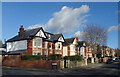
Houses on Mill Lane
South facing houses catching some winter afternoon sunshine.
Image: © Des Blenkinsopp
Taken: 19 Jan 2023
0.08 miles
5
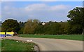
Development land, south Swindon
After years of debate, discussion and inquiries, development is at last going ahead on the controversial 'Front Garden' site just south of the Old Town area of Swindon. It is low lying land north of the M4 and reportedly prone to flooding. If anyone is sufficiently interested googling 'front garden swindon' will pull up lots of references. In this view to the north, the long-established Belmont Crescent area of large houses is visible at the top of the scarp. The road in the foreground is a haul road for construction vehicles.
Image: © Brian Robert Marshall
Taken: 14 Oct 2007
0.09 miles
6
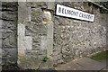
Benchmark on wall at Belmont Crescent junction
Ordnance Survey cut mark benchmark described on the Bench Mark Database at http://www.bench-marks.org.uk/bm40829
Image: © Roger Templeman
Taken: 5 Jan 2012
0.09 miles
7
Junction of Belmont Crescent and Westlecot Road
There is an OS benchmark Image on the wall pier left of the Belmont Crescent road name sign.
Image: © Roger Templeman
Taken: 5 Jan 2012
0.09 miles
8
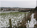
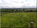
Fields to south of Swindon
Looking from the view point beside the former railway line over the new development on Swindon's 'front garden'.
Image: © Gareth James
Taken: 27 Dec 2010
0.10 miles
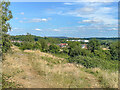
9
Looking south west from near the old railway track
Image: © Rob Purvis
Taken: 11 Jun 2013
0.10 miles
10
Towards Homeleaze
Looking across open grassland to Homeleaze, a development off Croft Road, completed in 2021. In the background is Nationwide House, the headquarters of the Nationwide Building Society.
Image: © Ian Capper
Taken: 14 Jul 2022
0.10 miles