IMAGES TAKEN NEAR TO
Grovelands Avenue, SWINDON, SN1 4EH
Introduction
This page details the photographs taken nearby to Grovelands Avenue, SN1 4EH by members of the Geograph project.
The Geograph project started in 2005 with the aim of publishing, organising and preserving representative images for every square kilometre of Great Britain, Ireland and the Isle of Man.

There are currently over 7.5m images from over14,400 individuals and you can help contribute to the project by visiting https://www.geograph.org.uk
Image Map
Images are licensed for reuse under creativecommons.org/licenses/by-sa/2.0
Notes
- Clicking on the map will re-center to the selected point.
- The higher the marker number, the further away the image location is from the centre of the postcode.
Image Listing (134 Images Found)
Images are licensed for reuse under creativecommons.org/licenses/by-sa/2.0
Image
Details
Distance
1
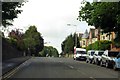
Westlecot Road bridge, Swindon
On the route of the former Midland & South Western Junction Railway, in Old Town, Swindon. This path is now part of National Cycle Network Route 45.
Image: © Gareth James
Taken: 27 Dec 2010
0.04 miles
2
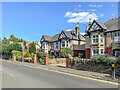
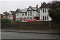
Springfield Road
Pair of early 20th Century semi-detached villas in Springfield Road.
Image: © Ian Capper
Taken: 14 Jul 2022
0.04 miles
3
Sunlight and shade under Westlecot Road
The former Midland & South Western Junction Railway, which runs west-east along the southern edge of Swindon and is now part of NCR 45.
Image: © Christine Johnstone
Taken: 14 Jul 2022
0.04 miles
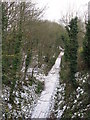
4
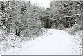
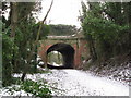
Old Town Rail Path near Springfield Road Bridge, in winter
At this point the former railway line ran in this deep cutting, and then passed under the bridge carrying Springfield Road over it. Today it is a cycleway and public footpath. Image
Image: © P L Chadwick
Taken: Unknown
0.04 miles
5
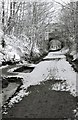
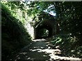
Old Town Rail Path near Springfield Road Bridge, in winter
Just before the bridge is a fingerpost pointing to a path on the right. This gives access to Bowling Green Lane and Springfield Road. The last trains travelled along here about 40 years or so ago. For a view of the path on the other side of the bridge:- Image
Image: © P L Chadwick
Taken: Unknown
0.05 miles
6
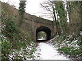
Westlecot Road bridge, Swindon
On the route of the former Midland & South Western Junction Railway, in Old Town, Swindon. This path is now part of National Cycle Network Route 45.
Image: © Gareth James
Taken: 27 Dec 2010
0.06 miles
8
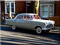
Ford, Westlecot Road, Swindon
An immaculate 1961 1703cc Ford Consul celebrates its 50th birthday in the afternoon sun in Old Town, Swindon. It probably didn't look this good when it left Dagenham (where I assume it was built).
Image: © Brian Robert Marshall
Taken: 13 Mar 2011
0.08 miles
9
Former MSWJ route, Swindon
The route of the former Midland & South Western Junction Railway near Swindon Town Station, viewed from Westlecot Road bridge. This path is now part of National Cycle Network Route 45.
Image: © Gareth James
Taken: 27 Dec 2010
0.08 miles