
IMAGES TAKEN NEAR TO
Croft Road, SWINDON, SN1 4DW
Introduction
This page details the photographs taken nearby to Croft Road, SN1 4DW by members of the Geograph project.
The Geograph project started in 2005 with the aim of publishing, organising and preserving representative images for every square kilometre of Great Britain, Ireland and the Isle of Man.

There are currently over 7.5m images from over14,400 individuals and you can help contribute to the project by visiting https://www.geograph.org.uk
Image Map
Images are licensed for reuse under creativecommons.org/licenses/by-sa/2.0
Notes
- Clicking on the map will re-center to the selected point.
- The higher the marker number, the further away the image location is from the centre of the postcode.
Image Listing (35 Images Found)
Images are licensed for reuse under creativecommons.org/licenses/by-sa/2.0
Image
Details
Distance
2
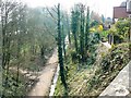
Former M&SWJ railway, Springfield Road, Swindon
Facing south-west. The trackbed of what was once the Midland and South Western Junction Railway is now part of the National Cycle Network. The image was obtained from the road bridge over the old line.
Image: © Brian Robert Marshall
Taken: 28 Mar 2007
0.16 miles
4
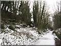
Former MSWJ route, Swindon
On the route of the former Midland & South Western Junction Railway, in Old Town, Swindon. This path is now part of National Cycle Network Route 45. Note the wide cutting and rock formations on the left.
Image: © Gareth James
Taken: 27 Dec 2010
0.16 miles
5
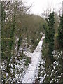
Former MSWJ route, Swindon
The route of the former Midland & South Western Junction Railway near Swindon Town Station, viewed from Westlecot Road bridge. This path is now part of National Cycle Network Route 45.
Image: © Gareth James
Taken: 27 Dec 2010
0.17 miles
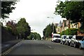
7
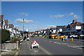
Road Works along Croft Road
A small excavation going on very efficiently without temporary traffic lights and several thousand cones.
Image: © Des Blenkinsopp
Taken: 10 Oct 2022
0.17 miles
8

Rock face in a former railway cutting, Swindon
Limestone, I think. This is the former Midland & South Western Junction Railway, which runs west-east along the southern edge of Swindon and is now part of NCR 45.
Image: © Christine Johnstone
Taken: 14 Jul 2022
0.18 miles
9
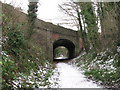
Westlecot Road bridge, Swindon
On the route of the former Midland & South Western Junction Railway, in Old Town, Swindon. This path is now part of National Cycle Network Route 45.
Image: © Gareth James
Taken: 27 Dec 2010
0.19 miles
10
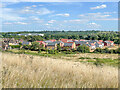
Homeleaze
Looking across open grassland to Homeleaze, a development off Croft Road, completed in 2021. In the left background is Nationwide House, the headquarters of the Nationwide Building Society.
Image: © Ian Capper
Taken: 14 Jul 2022
0.19 miles