IMAGES TAKEN NEAR TO
Bath Road, SWINDON, SN1 4AT
Introduction
This page details the photographs taken nearby to Bath Road, SN1 4AT by members of the Geograph project.
The Geograph project started in 2005 with the aim of publishing, organising and preserving representative images for every square kilometre of Great Britain, Ireland and the Isle of Man.

There are currently over 7.5m images from over14,400 individuals and you can help contribute to the project by visiting https://www.geograph.org.uk
Image Map
Images are licensed for reuse under creativecommons.org/licenses/by-sa/2.0
Notes
- Clicking on the map will re-center to the selected point.
- The higher the marker number, the further away the image location is from the centre of the postcode.
Image Listing (180 Images Found)
Images are licensed for reuse under creativecommons.org/licenses/by-sa/2.0
Image
Details
Distance
1
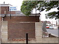
Moose Centre
Moose International is an organisation that began in the U.S.A. with the intention to help and support the widowed and orphaned. It crossed the Atlantic and was known here as The Grand Lodge of the Loyal Order of Moose in Great Britain, but the aims remain the same. Just don't expect to see a moose, though.
Image: © Neil Owen
Taken: 4 Sep 2014
0.01 miles
2
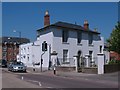
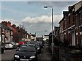
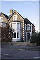
House on Bath Road
The eastern end of Bath Road has a few pleasant houses of the early 19th century, most of which are now offices. This one looks as though it should be of around 1840 and stands by the corner of Eastcott Road.
Image: © Gordon Hatton
Taken: 3 Jun 2010
0.04 miles
3
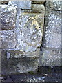
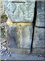
Benchmark on end of party wall of #53/55 Bath Road
Ordnance Survey cut mark benchmark described on the Bench Mark Database at http://www.bench-marks.org.uk/bm37358
Image: © Roger Templeman
Taken: 18 Mar 2011
0.05 miles
4
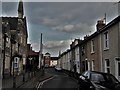
King William Street, Old Town, Swindon
The buildings on the left belong to the primary school of the same name.
Image: © Chris Brown
Taken: 21 Mar 2018
0.07 miles
6
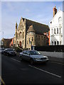
Bath Road Methodist Church Old Town Swindon
Image: © Peter Watkins
Taken: 21 Jan 2006
0.08 miles
7
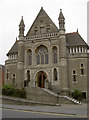
Bath Road Methodist Church
The Wesleyan congregation of Swindon were rapidly running out of space in the 1800s, so it was agreed to build a new church on the Bath Road. Joseph Armstrong, W.V. Edward and P.H. Mason donated some of the land, with an additional piece of ground bought for £540. Architects Bromilow & Chears of Liverpool were engaged to draw up the plans and Thomas Barrett, a loyal member of the church and who was renowned for building Blunsdon Abbey in 1864, was contracted to carry out the construction.
On 16 April 1879, the foundation stone was laid, with a time-capsule, and a tea for 500 people was held in The Corn Exchange. The total cost amounted to £5,631, a lot of which was funded by subscriptions. The official opening took place at 3 p.m. on Whit Monday, 17 May 1880; dedication services and special events lasted for 23 days.
After a century of worship, the church fabric was in great need of attention; indeed, it was in danger of needing demolition. But after much fund-raising the church was saved and reopened on 3rd December, 1984
Image: © Neil Owen
Taken: 4 Sep 2014
0.08 miles
8
Bath Road Methodist Church Old Town Swindon
Recreating this ‘First’ for the square https://www.geograph.org.uk/photo/110348 . Methodist chapel. c1880, by Bromilow and Cheers of Liverpool, altered 1983. Listed Grade II.
Image: © Alan Murray-Rust
Taken: 14 Jul 2022
0.08 miles
9
Benchmark on end of party wall between #58/60 Bath Road
Ordnance Survey cut mark benchmark described on the Bench Mark Database at http://www.bench-marks.org.uk/bm37359
Image: © Roger Templeman
Taken: 18 Mar 2011
0.09 miles
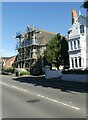
10
#60 Bath Road
There is an OS benchmark Image on the road end of the party wall with #58
Image: © Roger Templeman
Taken: 5 Jan 2012
0.09 miles