IMAGES TAKEN NEAR TO
Poplar Way, CHIPPENHAM, SN14 8PP
Introduction
This page details the photographs taken nearby to Poplar Way, SN14 8PP by members of the Geograph project.
The Geograph project started in 2005 with the aim of publishing, organising and preserving representative images for every square kilometre of Great Britain, Ireland and the Isle of Man.

There are currently over 7.5m images from over14,400 individuals and you can help contribute to the project by visiting https://www.geograph.org.uk
Image Map (Loading...)


Getting Data...Please wait
Leaflet Map data © OpenStreetMap
Images are licensed for reuse under creativecommons.org/licenses/by-sa/2.0
Notes
- Clicking on the map will re-center to the selected point.
- The higher the marker number, the further away the image location is from the centre of the postcode.
Image Listing (4 Images Found)
Images are licensed for reuse under creativecommons.org/licenses/by-sa/2.0
Image
Details
Distance
1
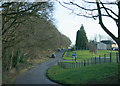
2009 : South east on Doncombe Lane
The entrance to Colerne Airfield is to the left.
Image] shows the same scene from the opposite direction.
Image: © Maurice Pullin
Taken: 18 Jan 2009
0.11 miles
2
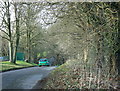
2009 : North west on Doncombe Lane
R.A.F. Colerne is beyond the fence to the left.
Image: © Maurice Pullin
Taken: 18 Jan 2009
0.12 miles
3
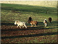
2009 : Ponies in a field, Doncombe Lane
As soon as they saw me they came at a gallop.
Image: © Maurice Pullin
Taken: 18 Jan 2009
0.14 miles
4
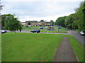
Doncombe Lane
A view looking to the northwest along Doncombe Lane towards the main entrance to Azimghur Barracks as Colerne airfield is now called.
Image: © Phil Williams
Taken: 15 May 2006
0.19 miles