IMAGES TAKEN NEAR TO
High Street, CHIPPENHAM, SN14 8LR
Introduction
This page details the photographs taken nearby to High Street, SN14 8LR by members of the Geograph project.
The Geograph project started in 2005 with the aim of publishing, organising and preserving representative images for every square kilometre of Great Britain, Ireland and the Isle of Man.

There are currently over 7.5m images from over14,400 individuals and you can help contribute to the project by visiting https://www.geograph.org.uk
Image Map
Images are licensed for reuse under creativecommons.org/licenses/by-sa/2.0
Notes
- Clicking on the map will re-center to the selected point.
- The higher the marker number, the further away the image location is from the centre of the postcode.
Image Listing (123 Images Found)
Images are licensed for reuse under creativecommons.org/licenses/by-sa/2.0
Image
Details
Distance
1
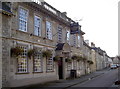
The Catherine Wheel
Considering Marshfield had a massive malting industry in times past, it is not surprising that there are a number of old pubs. The Catherine Wheel was originally listed as an inn from about 1755, when it was known as The Star. It offered coaching facilities and, like others in the village, suffered from various financial problems; the inn changed hands many times. By around 1790, it was renamed The Catherine Wheel and also had its own malting house attached. In the latter part of the nineteenth century, the inn also served as the Inland Revenue office! By 1900 it relinquished its free house status and sold the rights to a local brewery.
Image: © Neil Owen
Taken: 18 Oct 2016
0.00 miles
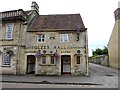
2
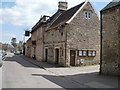
Marshfield, Tolzey Hall
On High Street, next to Image; judging from its name, probably originally a market courthouse, now parish offices upstairs, and public conveniences downstairs.
Image: © Mike Faherty
Taken: 20 Apr 2010
0.00 miles
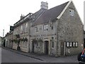
3
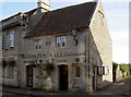
The Tolzey House
An immensely versatile little building is this. Originally built in 1690 by John and Mary Goslett for the good of the villagers of Marshfield, it served as an administrative centre (the parish council still meets here), local courthouse (Tolzey), lock-up and today is also a public convenience. It displays a number of plaques, mainly awards from the C.P.R.E. in recognition of Marshfield's beauty. See Image] for a look at the side.
Image: © Neil Owen
Taken: 18 Oct 2016
0.01 miles
4
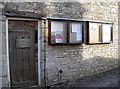
Parish minutes
The Tolzey Hall still serves Marshfield parish council as the meeting hall to this day, with the notice board an additional mouthpiece. See Image] for a look at the front.
Image: © Neil Owen
Taken: 18 Oct 2016
0.01 miles
5
Tolzey Hall, Marshfield
A useful (and historic) public building on Marshfield High Street.
Image: © Oliver Dixon
Taken: 30 Jun 2017
0.01 miles
6
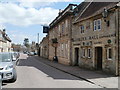
Marshfield, The Catherine Wheel
2010 Good Beer Guide-listed pub on High Street; earlyC17, with shell motif above entrance. Internally, central L-shaped bar, with drinking areas to front & right, dining rooms left and back. Some exposed stone, wooden beams, and a wheel above the bar. Cask ales on offer at my visit: Courage Best, Cotswold Spring Gloucester Glory, Sharp's Doom Bar. For some customer comments, see http://www.beerintheevening.com/pubs/s/28/28791/Catherine_Wheel/Marshfield
Image: © Mike Faherty
Taken: 20 Apr 2010
0.01 miles
7
Tolzey Hall
Tolzey Hall public conveniences and The Catherine Wheel.
Image: © don cload
Taken: 13 Sep 2010
0.01 miles
8
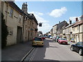
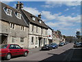
Marshfield High Street
A street patently not built for an age where almost every house has a car, plus public transport!
Image: © Mike Faherty
Taken: 20 Apr 2010
0.02 miles
9
Marshfield Post Office
On High Street, combined with butcher and greengrocer.
Image: © Mike Faherty
Taken: 20 Apr 2010
0.02 miles
10
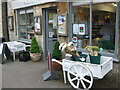
High Street country supplies
Some traditional street displays in Marshfield.
Image: © Neil Owen
Taken: 23 Jul 2022
0.02 miles