IMAGES TAKEN NEAR TO
Pennsylvania, CHIPPENHAM, SN14 8LE
Introduction
This page details the photographs taken nearby to SN14 8LE by members of the Geograph project.
The Geograph project started in 2005 with the aim of publishing, organising and preserving representative images for every square kilometre of Great Britain, Ireland and the Isle of Man.

There are currently over 7.5m images from over14,400 individuals and you can help contribute to the project by visiting https://www.geograph.org.uk
Image Map (Loading...)


Getting Data...Please wait
Leaflet Map data © OpenStreetMap
Images are licensed for reuse under creativecommons.org/licenses/by-sa/2.0
Notes
- Clicking on the map will re-center to the selected point.
- The higher the marker number, the further away the image location is from the centre of the postcode.
Image Listing (2 Images Found)
Images are licensed for reuse under creativecommons.org/licenses/by-sa/2.0
Image
Details
Distance
1
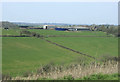
2010 : Oldfield Farm across the valley
Seen from the A420.
The valley contains the headwaters of Broadmead Brook which joins the By Brook near Castle Combe.
Image: © Maurice Pullin
Taken: 10 Apr 2010
0.02 miles
2
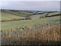
Oldfield Farm, near Cold Ashton, South Gloucestershire
The farm is on the hilltop to the left of the picture.
Image: © ChurchCrawler
Taken: 27 Dec 2005
0.06 miles