IMAGES TAKEN NEAR TO
Cold Ashton, CHIPPENHAM, SN14 8JU
Introduction
This page details the photographs taken nearby to SN14 8JU by members of the Geograph project.
The Geograph project started in 2005 with the aim of publishing, organising and preserving representative images for every square kilometre of Great Britain, Ireland and the Isle of Man.

There are currently over 7.5m images from over14,400 individuals and you can help contribute to the project by visiting https://www.geograph.org.uk
Image Map
Images are licensed for reuse under creativecommons.org/licenses/by-sa/2.0
Notes
- Clicking on the map will re-center to the selected point.
- The higher the marker number, the further away the image location is from the centre of the postcode.
Image Listing (99 Images Found)
Images are licensed for reuse under creativecommons.org/licenses/by-sa/2.0
Image
Details
Distance
1
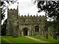
Old Rectory, Cold Ashton
Old Rectory which dates from the 16th century. It has an interesting history, being the place where Sir Bevil Grenville, Royalist leader in the English Civil War died, after being mortally wounded in the Battle of Lansdown in 1643. See http://www.geograph.org.uk/photo/1816688
Image: © Rick Crowley
Taken: 1 May 2010
0.01 miles
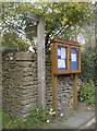
2
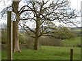
The Limestone Link
This inconspicuous signpost is in fact the start and end of the southers section of the Limestone Link; it stretches down to Shipham, some 36 miles hence.
Image: © Neil Owen
Taken: 5 Apr 2016
0.01 miles
3
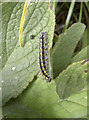
Striped caterpillar
Quietly but voraciously munching on the greenery in Cold Ashton, this appears to be the earthbound stage of a Scarlet Tiger moth (Callimorpha dominula). These brightly coloured creatures are mainly found in central and southern Britain.
Image: © Neil Owen
Taken: 5 Apr 2016
0.02 miles
4
A walk to the church and beyond
The path to Holy Trinity church is also part of the Limestone Link as it branches off the Cotswold Way.
Image: © Neil Owen
Taken: 5 Apr 2016
0.02 miles
5
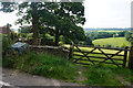
Footpath from Cold Ashton
The path is part of the Limestone Link. It goes into the valley of St Catherine's Brook which eventually meets the Avon at Batheaston.
Image: © Bill Boaden
Taken: 21 Jul 2016
0.02 miles
6
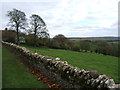
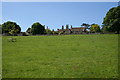
Pasture in Cold Ashton
A hillside pasture just south of Hyde's Lane in Cold Ashton.
Image: © Ruth Riddle
Taken: 6 Nov 2010
0.03 miles
7
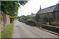
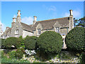
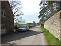
Cottages on Hyde's Lane
At the eastern end of the village of Cold Ashton.
Image: © Bill Boaden
Taken: 21 Jul 2016
0.03 miles
8
Hyde's Lane, Cold Ashton
The Cotswold Way, day five 10:36am
Image: © Ian S
Taken: 21 Apr 2013
0.03 miles
9
Old Rectory, Cold Ashton
Seen from the Limestone Link path.
Image: © Guy Wareham
Taken: 24 May 2010
0.04 miles