IMAGES TAKEN NEAR TO
West Littleton, CHIPPENHAM, SN14 8JA
Introduction
This page details the photographs taken nearby to SN14 8JA by members of the Geograph project.
The Geograph project started in 2005 with the aim of publishing, organising and preserving representative images for every square kilometre of Great Britain, Ireland and the Isle of Man.

There are currently over 7.5m images from over14,400 individuals and you can help contribute to the project by visiting https://www.geograph.org.uk
Image Map (Loading...)


Getting Data...Please wait
Leaflet Map data © OpenStreetMap
Images are licensed for reuse under creativecommons.org/licenses/by-sa/2.0
Notes
- Clicking on the map will re-center to the selected point.
- The higher the marker number, the further away the image location is from the centre of the postcode.
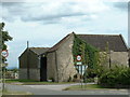
Image Listing (5 Images Found)
Images are licensed for reuse under creativecommons.org/licenses/by-sa/2.0
Image
Details
Distance
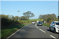
1
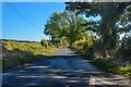
Dyrham : Dunsdown Lane
A lane off the A46.
Image: © Lewis Clarke
Taken: 18 Oct 2022
0.17 miles
3
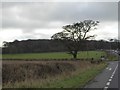
Shallow valley and Dunsdown Beeches
The OS map shows a stream rising just east of the main road, running between the side road and the woods
Image: © David Smith
Taken: 26 Nov 2016
0.20 miles
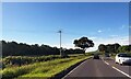
5
A46 heading north
Towards Stroud, although the old turnpike milestones use Cirencester as the destination, which now involves turning off onto the A433.
Image: © Robin Webster
Taken: 13 Nov 2022
0.25 miles