IMAGES TAKEN NEAR TO
Cleaves Avenue, CHIPPENHAM, SN14 8BX
Introduction
This page details the photographs taken nearby to Cleaves Avenue, SN14 8BX by members of the Geograph project.
The Geograph project started in 2005 with the aim of publishing, organising and preserving representative images for every square kilometre of Great Britain, Ireland and the Isle of Man.

There are currently over 7.5m images from over14,400 individuals and you can help contribute to the project by visiting https://www.geograph.org.uk
Image Map (Loading...)


Getting Data...Please wait
Leaflet Map data © OpenStreetMap
Images are licensed for reuse under creativecommons.org/licenses/by-sa/2.0
Notes
- Clicking on the map will re-center to the selected point.
- The higher the marker number, the further away the image location is from the centre of the postcode.
Image Listing (8 Images Found)
Images are licensed for reuse under creativecommons.org/licenses/by-sa/2.0
Image
Details
Distance
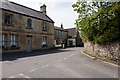
1
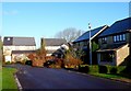
Cleaves Avenue, Colerne
A quiet modern residential street in this small Wiltshire village between Bath and Chippenham.
Image: © Nigel Mykura
Taken: 17 Dec 2009
0.05 miles
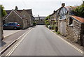
2
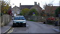
Seen better days
A motor on the Old Bath Road, Colerne.
Image: © Jonathan Billinger
Taken: 19 Nov 2013
0.12 miles
3
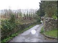
Washmeres
Looking down Washmeres Lane
Image: © Stephen Bashford
Taken: 3 Dec 2005
0.14 miles
6
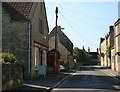
2008 : Post Office, High Street, Colerne
Image: © Maurice Pullin
Taken: 26 Sep 2008
0.20 miles
7
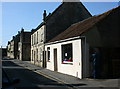
2008 : High Street, Colerne
To its villagers Colerne is known as ‘the village on the hill’ and this sums up both its position and much of its history. The parish lies on an upland spur of land with the valley of the By Brook to the south and east and a scarp slope to the north where the land drops steeply to North Wraxall. Much of the parish lies on limestone with Great Oolitic limestone in the north, which has been used for much of the local building. In the south, where the land falls away below the village, is an area of sands, rubbly limestone and some clay. Traditionally the higher land was used for sheep-rearing with corn and root crops grown on the lower.
The above was copied from: http://www.wiltshire.gov.uk/community/getcom.php?id=65 where you will find much more.
Image: © Maurice Pullin
Taken: 26 Sep 2008
0.22 miles