IMAGES TAKEN NEAR TO
Ashwicke, CHIPPENHAM, SN14 8AJ
Introduction
This page details the photographs taken nearby to SN14 8AJ by members of the Geograph project.
The Geograph project started in 2005 with the aim of publishing, organising and preserving representative images for every square kilometre of Great Britain, Ireland and the Isle of Man.

There are currently over 7.5m images from over14,400 individuals and you can help contribute to the project by visiting https://www.geograph.org.uk
Image Map
Images are licensed for reuse under creativecommons.org/licenses/by-sa/2.0
Notes
- Clicking on the map will re-center to the selected point.
- The higher the marker number, the further away the image location is from the centre of the postcode.
Image Listing (4 Images Found)
Images are licensed for reuse under creativecommons.org/licenses/by-sa/2.0
Image
Details
Distance
1
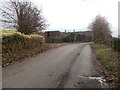
Ashwicke Home Farm
Presumably once owned by Ashwicke Hall nearby.
Image: © HelenK
Taken: 24 Nov 2016
0.02 miles
2
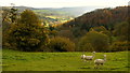
View over Motcombe
I think these long-necked sheep must be alpacas.
They have a field with a view for sure.
Image: © Jonathan Billinger
Taken: 19 Nov 2013
0.07 miles
3
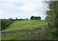
2008 : Looking toward Motcombe Farm
Seen from Ashwicke Road.
The land to the left slopes down to one of the many combes leading to St.Catherine's Valley.
Image: © Maurice Pullin
Taken: 7 Nov 2008
0.12 miles
4
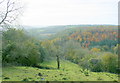
2008 : South from Ashwicke Road
The combe before us runs into St.Catherine's Valley a little over 1km from here.
Little Solsbury Hill Image can be seen at centre horizon but is not easily identified.
Image: © Maurice Pullin
Taken: 7 Nov 2008
0.19 miles