IMAGES TAKEN NEAR TO
Ashwicke, CHIPPENHAM, SN14 8AH
Introduction
This page details the photographs taken nearby to SN14 8AH by members of the Geograph project.
The Geograph project started in 2005 with the aim of publishing, organising and preserving representative images for every square kilometre of Great Britain, Ireland and the Isle of Man.

There are currently over 7.5m images from over14,400 individuals and you can help contribute to the project by visiting https://www.geograph.org.uk
Image Map
Images are licensed for reuse under creativecommons.org/licenses/by-sa/2.0
Notes
- Clicking on the map will re-center to the selected point.
- The higher the marker number, the further away the image location is from the centre of the postcode.
Image Listing (4 Images Found)
Images are licensed for reuse under creativecommons.org/licenses/by-sa/2.0
Image
Details
Distance
1
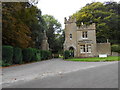
East Lodge to Ashwicke Hall
This lodge located at an angle and to and right next to the Fosse Way is now the main entrance to Sabis School which is now located in the hall. The lodge was built in 1857-1860 as well as the current main house to designs by James Kellaway Colling, who also designed the stable. The Sabis school is a private education school that was first started in the 19th C in Lebanon.
Image: © Nigel Mykura
Taken: 16 Sep 2012
0.01 miles
2
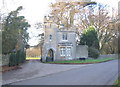
International School of Choueifat
A view looking northwest across the Fosse Way to the East Lodge entrance to the International School of Choueifat, established in 1886 according to the sign on the verge.
Image: © Phil Williams
Taken: 20 Jan 2006
0.06 miles
3
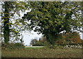
2008 : From Ashwicke Road
At the top of Oakford Lane.
Image: © Maurice Pullin
Taken: 7 Nov 2008
0.23 miles
4
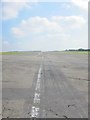
The SW end of the main runway on Colerne airfield
Image: © Dr Duncan Pepper
Taken: 8 Aug 2015
0.23 miles