IMAGES TAKEN NEAR TO
Ashwicke Road, CHIPPENHAM, SN14 8AD
Introduction
This page details the photographs taken nearby to Ashwicke Road, SN14 8AD by members of the Geograph project.
The Geograph project started in 2005 with the aim of publishing, organising and preserving representative images for every square kilometre of Great Britain, Ireland and the Isle of Man.

There are currently over 7.5m images from over14,400 individuals and you can help contribute to the project by visiting https://www.geograph.org.uk
Image Map (Loading...)


Getting Data...Please wait
Leaflet Map data © OpenStreetMap
Images are licensed for reuse under creativecommons.org/licenses/by-sa/2.0
Notes
- Clicking on the map will re-center to the selected point.
- The higher the marker number, the further away the image location is from the centre of the postcode.
Image Listing (5 Images Found)
Images are licensed for reuse under creativecommons.org/licenses/by-sa/2.0
Image
Details
Distance
1
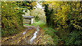
Watery Lane
Appropriately-named green lane pictured at Fuddlebrook Farm.
Image: © Jonathan Billinger
Taken: 19 Nov 2013
0.01 miles
2
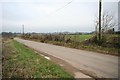
Lane
Lane heading towards Marshfield at Poulsen's Farm.
Image: © Derek Hawkins
Taken: 18 Feb 2007
0.23 miles
3
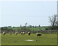
2010 : Six standing sheep in a field near Marshfield
Image: © Maurice Pullin
Taken: 10 Apr 2010
0.23 miles
4
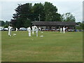
Warming up the attack
Marshfield Cricket Club are about to start the innings in the field, so the quickies are warming up.
Image: © Neil Owen
Taken: 23 Jul 2022
0.25 miles
5
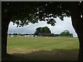
Marshfield cricket ground
Viewed from the boundary near the memorial to clubman Doug Moules.
Image: © Neil Owen
Taken: 23 Jul 2022
0.25 miles