IMAGES TAKEN NEAR TO
Toll Down Way, CHIPPENHAM, SN14 7PD
Introduction
This page details the photographs taken nearby to Toll Down Way, SN14 7PD by members of the Geograph project.
The Geograph project started in 2005 with the aim of publishing, organising and preserving representative images for every square kilometre of Great Britain, Ireland and the Isle of Man.

There are currently over 7.5m images from over14,400 individuals and you can help contribute to the project by visiting https://www.geograph.org.uk
Image Map
Images are licensed for reuse under creativecommons.org/licenses/by-sa/2.0
Notes
- Clicking on the map will re-center to the selected point.
- The higher the marker number, the further away the image location is from the centre of the postcode.
Image Listing (78 Images Found)
Images are licensed for reuse under creativecommons.org/licenses/by-sa/2.0
Image
Details
Distance
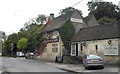
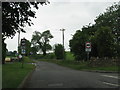
2
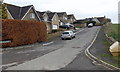
Toll Down Way, Burton
A cul-de-sac in the west of the village.
Image: © Jaggery
Taken: 24 Nov 2013
0.03 miles
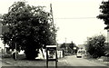
9
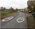
Change of speed limit in Burton
The 40mph speed limit along the B4039 reduces to 30mph on the approach to the main residential part of the village.
Image: © Jaggery
Taken: 24 Nov 2013
0.04 miles