IMAGES TAKEN NEAR TO
Castle Combe, CHIPPENHAM, SN14 7HZ
Introduction
This page details the photographs taken nearby to SN14 7HZ by members of the Geograph project.
The Geograph project started in 2005 with the aim of publishing, organising and preserving representative images for every square kilometre of Great Britain, Ireland and the Isle of Man.

There are currently over 7.5m images from over14,400 individuals and you can help contribute to the project by visiting https://www.geograph.org.uk
Image Map (Loading...)


Getting Data...Please wait
Leaflet Map data © OpenStreetMap
Images are licensed for reuse under creativecommons.org/licenses/by-sa/2.0
Notes
- Clicking on the map will re-center to the selected point.
- The higher the marker number, the further away the image location is from the centre of the postcode.
Image Listing (12 Images Found)
Images are licensed for reuse under creativecommons.org/licenses/by-sa/2.0
Image
Details
Distance
1
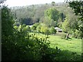
Valley containing Colham Mill
From a footpath running through light woodland above the valley, we look down on the buildings of Colham Mill in the south-west corner of the square.
Image: © Graham Horn
Taken: 2 May 2007
0.01 miles
2
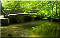
Castle Combe, Wiltshire 2013
Bridge locally called The Roman Bridge over By-brook
Image: © Ray Bird
Taken: Unknown
0.12 miles
3
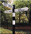
Old Direction Sign - Signpost in Castle Combe parish
Pyramid top finial - 3 arms; Wilts wooden by the C151, in parish of Castle Combe (North Wiltshire District), between Castle Combe and Ford, on grass inside fork on road.
To be surveyed
Milestone Society National ID: WI_ST8376
Image: © Milestone Society
Taken: Unknown
0.13 miles
4
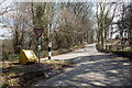
Road Junction
This is the junction between the minor road to Shrub Farm behind the point of view and the roads to Castle Combe and Ford. "The Street" to the left descends to Castle Combe, the road ahead goes to Ford.
Image: © Doug Lee
Taken: 31 Mar 2013
0.14 miles
5
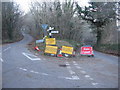
Road closure on the lane to Castle Combe
A view looking to the north towards a junction on the lane from Ford to Castle Combe, with a temporary road closure in place.
Image: © Phil Williams
Taken: 6 Feb 2007
0.14 miles
6

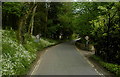
Road junction on the road to Castle Combe
The only road into Castle Combe from the south pursues a very hilly course rather than following the valley. Compare with the winter scene of the same junction Image
Image: © Oliver Dixon
Taken: 5 Jul 2017
0.14 miles
7
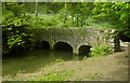
Castle Combe, Wiltshire 2013
Bridge locally called Roman Bridge over By-brook
Image: © Ray Bird
Taken: Unknown
0.16 miles
10
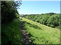
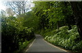
Path on Danks Down
This path forms part of the Palladian Way, a 190 km path from Buckingham to Bath which takes in a number of stately homes built in the Palladian style.
Image: © Oliver Dixon
Taken: 5 Jul 2017
0.23 miles