IMAGES TAKEN NEAR TO
SN14 7FF
Introduction
This page details the photographs taken nearby to SN14 7FF by members of the Geograph project.
The Geograph project started in 2005 with the aim of publishing, organising and preserving representative images for every square kilometre of Great Britain, Ireland and the Isle of Man.

There are currently over 7.5m images from over14,400 individuals and you can help contribute to the project by visiting https://www.geograph.org.uk
Image Map
Images are licensed for reuse under creativecommons.org/licenses/by-sa/2.0
Notes
- Clicking on the map will re-center to the selected point.
- The higher the marker number, the further away the image location is from the centre of the postcode.
Image Listing (7 Images Found)
Images are licensed for reuse under creativecommons.org/licenses/by-sa/2.0
Image
Details
Distance
1
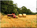
Farmland and Machinery near Littleton Drew
This field is on the east side of the road in the north eastern section of the square.
Image: © Pam Brophy
Taken: 23 Aug 2005
0.03 miles
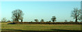
3

Fields near Littleton Drew
Viewed from the M4, with scattered trees along the field boundaries.
Image: © Derek Harper
Taken: 11 Jul 2014
0.16 miles
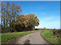
4
Trees along field boundaries near Littleton Drew
Several of these trees can be seen on the right of Image
Image: © Derek Harper
Taken: 19 Jan 2018
0.17 miles
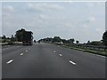
5

Wiltshire : M4 Motorway
The M4 Motorway between Junction 18 (Tormarton Interchange) and Junction 17 (Stanton St Quinton).
Image: © Lewis Clarke
Taken: 23 Mar 2018
0.22 miles
6
M4 Motorway near Littleton Drew
The parapet of the bridge carrying the lane from Littleton Drew is clearly visible on the left.
Image: © J Whatley
Taken: 22 Sep 2010
0.22 miles
7
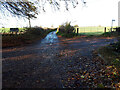
Road junction at Fosse Gate
Here the Fosse Way coming from the right rejoins the main road, and continues on to the left, while the minor road to Littleton Drew lies straight ahead.
Image: © Vieve Forward
Taken: 12 Nov 2020
0.23 miles