IMAGES TAKEN NEAR TO
The Street, CHIPPENHAM, SN14 7BA
Introduction
This page details the photographs taken nearby to The Street, SN14 7BA by members of the Geograph project.
The Geograph project started in 2005 with the aim of publishing, organising and preserving representative images for every square kilometre of Great Britain, Ireland and the Isle of Man.

There are currently over 7.5m images from over14,400 individuals and you can help contribute to the project by visiting https://www.geograph.org.uk
Image Map
Images are licensed for reuse under creativecommons.org/licenses/by-sa/2.0
Notes
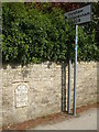
- Clicking on the map will re-center to the selected point.
- The higher the marker number, the further away the image location is from the centre of the postcode.
Image Listing (53 Images Found)
Images are licensed for reuse under creativecommons.org/licenses/by-sa/2.0
Image
Details
Distance
1
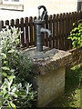
An old pump
This old pump appears to bear little information, but the 1900 map shows it to be a genuine water source and not a garden ornament.
Image: © Neil Owen
Taken: 29 Apr 2019
0.01 miles
2
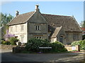
Old School Gardens
This lovely Cotswold stone building was, until quite recently, the village school. Originally founded in March, 1859, it took in local children to give them what was often an inconsistent education in early days. Pupils' abilities and teaching facilities varied quite widely and standards were sometimes compromised by other (typically farming related) activities in the village. However, the school continued to improve and kept running for many years until the latter twentieth century.
By the early 1980s pupil numbers had reached a low level, but these grew from then on. Extra classroom space was added with temporary cabins but moves were made to create a new school that would attract pupils from neighbouring villages for efficiency. As a result the new school was built by the recreation ground and the old school closed in 1998. It is now a private residence.
Image: © Neil Owen
Taken: 29 Apr 2019
0.04 miles
5
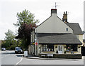
2009 : Post Office and store, Yatton Keynell
The B4039 departs to the left heading for the A420 and Chippenham, Biddestone Lane, a minor road, leaves to the right.
Some of Yatton Kaynell's interesting history in: http://en.wikipedia.org/wiki/Yatton_Keynell
Image: © Maurice Pullin
Taken: 10 May 2009
0.10 miles
6
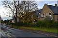
Not the most popular of footpaths
Somehow this could allow access to the back of Street Farm.
Image: © Neil Owen
Taken: 29 Apr 2019
0.10 miles
7
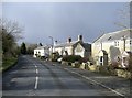
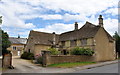
Cottages at Yatton Keynell
On the main road south to Chippenham.
Image: © Roger Cornfoot
Taken: 22 Jan 2007
0.11 miles
8
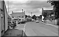
B4039 through Yatton Keynell, Wiltshire 2016
Image: © Ray Bird
Taken: 3 Aug 2016
0.12 miles
9
Directing travellers down the ages
Yatton Keynell's old milestone and a modern traffic sign. Interestingly, the milestone is of an ages that refers to a particular part of London and not the more obvious ones.
Image: © Neil Owen
Taken: 29 Apr 2019
0.12 miles
10

Old Milestone by the B4039, The Street in Yatton Keynell
Metal plate attached to stone post by the B4039, in parish of YATTON KEYNELL (NORTH WILTSHIRE District), The Street; opposite the Post Office and junction with Biddestone Lane, inset into wall, on East side of road. Old Sodbury plate, erected by the Sodbury Division turnpike trust in the 19th century.
Inscription reads:-
97
Miles
to
Hyde Park
Corner
to
Sodbury
11
Grade II listed.
List Entry Number: 1023026 https://historicengland.org.uk/listing/the-list/list-entry/1023026
Milestone Society National ID: WI_CSCP11.
Image: © M Faherty
Taken: 8 Jun 2008
0.12 miles