IMAGES TAKEN NEAR TO
Lower North Wraxall, CHIPPENHAM, SN14 7AX
Introduction
This page details the photographs taken nearby to SN14 7AX by members of the Geograph project.
The Geograph project started in 2005 with the aim of publishing, organising and preserving representative images for every square kilometre of Great Britain, Ireland and the Isle of Man.

There are currently over 7.5m images from over14,400 individuals and you can help contribute to the project by visiting https://www.geograph.org.uk
Image Map
Images are licensed for reuse under creativecommons.org/licenses/by-sa/2.0
Notes
- Clicking on the map will re-center to the selected point.
- The higher the marker number, the further away the image location is from the centre of the postcode.
Image Listing (2 Images Found)
Images are licensed for reuse under creativecommons.org/licenses/by-sa/2.0
Image
Details
Distance
1
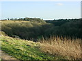
2009 : Valley between Truckle Hill and Ford Hill
Turning to the right from Image] the valley ahead has a small stream which joins the By Brook at Ford.
Truckle Hill is to the left and Ford Hill to the right.
Image: © Maurice Pullin
Taken: 18 Jan 2009
0.10 miles