IMAGES TAKEN NEAR TO
Luckington, CHIPPENHAM, SN14 6NU
Introduction
This page details the photographs taken nearby to SN14 6NU by members of the Geograph project.
The Geograph project started in 2005 with the aim of publishing, organising and preserving representative images for every square kilometre of Great Britain, Ireland and the Isle of Man.

There are currently over 7.5m images from over14,400 individuals and you can help contribute to the project by visiting https://www.geograph.org.uk
Image Map
Images are licensed for reuse under creativecommons.org/licenses/by-sa/2.0
Notes
- Clicking on the map will re-center to the selected point.
- The higher the marker number, the further away the image location is from the centre of the postcode.
Image Listing (91 Images Found)
Images are licensed for reuse under creativecommons.org/licenses/by-sa/2.0
Image
Details
Distance
2
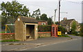
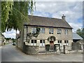
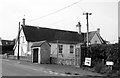
Bus Shelter & Phonebox, Luckington, Wiltshire 2013
Image: © Ray Bird
Taken: 25 Sep 2013
0.01 miles
3
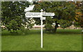
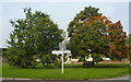
Signpost on Village Green, Luckington, Wiltshire 2013
Image: © Ray Bird
Taken: 25 Sep 2013
0.01 miles
4
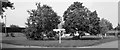
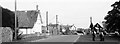
The Village Green, Luckington, Wiltshire 2013
Image: © Ray Bird
Taken: 25 Sep 2013
0.01 miles
5
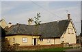
Primary School, Luckington, Wiltshire 2013
Image: © Ray Bird
Taken: 25 Sep 2013
0.01 miles
6
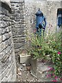
Cast iron pump
The pump which gives the pump house its name. See Image
Image: © Alan Hughes
Taken: 13 Jul 2022
0.02 miles
9
Primary School, Luckington, Wiltshire 2013
Image: © Ray Bird
Taken: 25 Sep 2013
0.02 miles
10
The Village Green, Luckington, Wiltshire 2013
Image: © Ray Bird
Taken: 25 Sep 2013
0.02 miles