IMAGES TAKEN NEAR TO
Allington, CHIPPENHAM, SN14 6LU
Introduction
This page details the photographs taken nearby to SN14 6LU by members of the Geograph project.
The Geograph project started in 2005 with the aim of publishing, organising and preserving representative images for every square kilometre of Great Britain, Ireland and the Isle of Man.

There are currently over 7.5m images from over14,400 individuals and you can help contribute to the project by visiting https://www.geograph.org.uk
Image Map
Images are licensed for reuse under creativecommons.org/licenses/by-sa/2.0
Notes
- Clicking on the map will re-center to the selected point.
- The higher the marker number, the further away the image location is from the centre of the postcode.
Image Listing (6 Images Found)
Images are licensed for reuse under creativecommons.org/licenses/by-sa/2.0
Image
Details
Distance
1

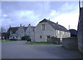
2010 : Outbuildings at Fowlswick Farm
Some evidence of early settlement in this area: http://history.wiltshire.gov.uk/smr/getsmr.php?id=2069
Image: © Maurice Pullin
Taken: 16 Mar 2010
0.09 miles
2
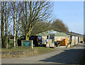
Fowlswick farm
The farm buildings have been used to create a rural business centre.
Image: © Roger Cornfoot
Taken: 22 Jan 2007
0.12 miles
3
2010 : Fowlswick Business Park (and farm)
Good to see a bit of local enterprise: http://www.yell.com/b/Fowlswick+Business+Park-Offices+_+Rental-Chippenham-SN146LT-2193499/index.html
Image: © Maurice Pullin
Taken: 16 Mar 2010
0.12 miles
4

2010 : Ancient and fairly modern
Barns opposite Fowlswick Farm.
Image: © Maurice Pullin
Taken: 16 Mar 2010
0.13 miles
5
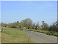
2010 : Road to Kington St.Michael
Near Fowlswick Farm.
Image: © Maurice Pullin
Taken: 16 Mar 2010
0.17 miles
6
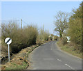
2010 : The road to Kington St.Michael
Seen from the junction with the B4039.
Heading north east, made a useful ratrun round Chippenham before the bypass was built.
Image: © Maurice Pullin
Taken: 16 Mar 2010
0.22 miles