IMAGES TAKEN NEAR TO
Hullavington, CHIPPENHAM, SN14 6EU
Introduction
This page details the photographs taken nearby to SN14 6EU by members of the Geograph project.
The Geograph project started in 2005 with the aim of publishing, organising and preserving representative images for every square kilometre of Great Britain, Ireland and the Isle of Man.

There are currently over 7.5m images from over14,400 individuals and you can help contribute to the project by visiting https://www.geograph.org.uk
Image Map
Images are licensed for reuse under creativecommons.org/licenses/by-sa/2.0
Notes
- Clicking on the map will re-center to the selected point.
- The higher the marker number, the further away the image location is from the centre of the postcode.
Image Listing (8 Images Found)
Images are licensed for reuse under creativecommons.org/licenses/by-sa/2.0
Image
Details
Distance
3
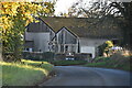
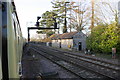
The Stationmaster's House, Hullavington
The Paddington / South Wales main line passes over the road, but is hidden by the trees.
As this is still called The Stationmaster's House, there must have been a station here! But all these smaller halts disappeared at the time of the Beeching cuts (if not before; the station here was, I suspect, primarily for military use) and on this line there is now no stop between Swindon and Bristol Parkway.
The house has, I assume, been extended since the GWR built it.
Image: © David Purchase
Taken: 28 Jun 2011
0.11 miles
4

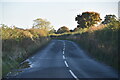
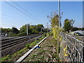
Site of Hullavington station, 1995
View northward on road to Norton, under bridge conveying the ex-GWR main line from London, Swindon etc. (to left) to South Wales via the Severn Tunnel (to right), also Bristol via Filton Junction, the 'Badminton line'. The station had been up to the right, until closed to passengers 3/4/61, to goods 4/10/65. (My Honda Accord features).
Image: © Ben Brooksbank
Taken: 26 Apr 1995
0.15 miles
5
Charter train leaves Hullavington Down Goods Loop
With the red signal protecting the down main line it is safe for the charter to continue west.
Image: © Roger Templeman
Taken: 14 Jan 2012
0.16 miles
6
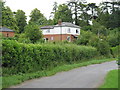
Hullavington railway station (site), Wiltshire
Opened in 1903 by the Great Western Railway on the line from Swindon to South Wales via the Severn Tunnel, this station closed in 1961 to passengers, and completely in 1965.
View west along the platform remains towards Badminton and the Severn Tunnel, a few months after the electric wires had been erected. Little trace of the station survives.
Image: © Nigel Thompson
Taken: 10 Oct 2018
0.18 miles
7
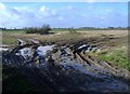
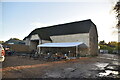
Bradfield Manor farm
A large expanse of arable land, north of Hullavington.
Image: © Roger Cornfoot
Taken: 20 Jan 2007
0.20 miles