IMAGES TAKEN NEAR TO
Grittleton, CHIPPENHAM, SN14 6AU
Introduction
This page details the photographs taken nearby to SN14 6AU by members of the Geograph project.
The Geograph project started in 2005 with the aim of publishing, organising and preserving representative images for every square kilometre of Great Britain, Ireland and the Isle of Man.

There are currently over 7.5m images from over14,400 individuals and you can help contribute to the project by visiting https://www.geograph.org.uk
Image Map
Images are licensed for reuse under creativecommons.org/licenses/by-sa/2.0
Notes
- Clicking on the map will re-center to the selected point.
- The higher the marker number, the further away the image location is from the centre of the postcode.
Image Listing (8 Images Found)
Images are licensed for reuse under creativecommons.org/licenses/by-sa/2.0
Image
Details
Distance
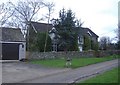
2
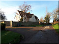
Surrendell Farm
The farmhouse and associated buildings, were undergoing extensive refurbishment at this time.
Image: © Roger Cornfoot
Taken: 1 Feb 2007
0.04 miles
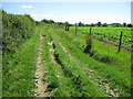
4
Ruts on the Byway
Some deep tractor ruts have been filled with rubble on the byway down the side of the field.
Image: © James Ayres
Taken: 26 Jun 2011
0.20 miles
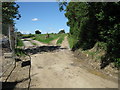
5
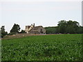
Looking south along the byway
The building covered in scaffolding in the distance is Surrendell Cottage - currently being renovated.
Image: © James Ayres
Taken: 26 Jun 2011
0.20 miles
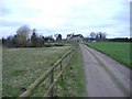
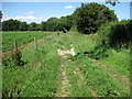
6
Surrendell Farm Byway
The right fork is the Byway Open to All Traffic that leads to Pig Lane
Image: © James Ayres
Taken: 26 Jun 2011
0.22 miles
7
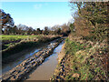
Surrendell Cottage
Close to Gauze Brook, at the end of the lane, from Hullavington.
Image: © Roger Cornfoot
Taken: 1 Feb 2007
0.23 miles