IMAGES TAKEN NEAR TO
Alderton Road, CHIPPENHAM, SN14 6AN
Introduction
This page details the photographs taken nearby to Alderton Road, SN14 6AN by members of the Geograph project.
The Geograph project started in 2005 with the aim of publishing, organising and preserving representative images for every square kilometre of Great Britain, Ireland and the Isle of Man.

There are currently over 7.5m images from over14,400 individuals and you can help contribute to the project by visiting https://www.geograph.org.uk
Image Map (Loading...)


Getting Data...Please wait
Leaflet Map data © OpenStreetMap
Images are licensed for reuse under creativecommons.org/licenses/by-sa/2.0
Notes
- Clicking on the map will re-center to the selected point.
- The higher the marker number, the further away the image location is from the centre of the postcode.
Image Listing (80 Images Found)
Images are licensed for reuse under creativecommons.org/licenses/by-sa/2.0
Image
Details
Distance
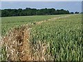
1
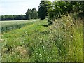
Footpath near Grittleton
The footpath takes walkers along the field headland back towards the village.
Image: © Maigheach-gheal
Taken: 1 Jul 2009
0.03 miles
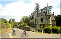
2
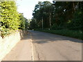
Alderton Road, Grittleton
Alderton Road is the only road in this square. The village of Grittleton does not appear to have anything that would qualify as 'affordable housing', probably because of its easy access to junction 17 of the M4. The homes in which farm labourers would once have lived must either have been demolished or have been knocked together to make larger houses, giving it a slightly unreal, model-village feel.
Image: © HelenK
Taken: 20 Jul 2021
0.07 miles
3
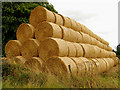
Straw Bales in Grittleton
This square is mostly farmland, with a minor road and some footpaths, as well as some residences of the village of Grittleton. These straw bales were stacked outside the barn, in the south eastern corner of the square and south of the footpath.
Image: © Pam Brophy
Taken: 23 Aug 2005
0.07 miles
4
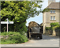
2010 : Farm vehicle at Grittleton crossroads
Heading north in the direction of Tetbury but I doubt he will get that far.
For destinations left and right see the signpost.
The road behind is from Yatton Keynell.
The tractor was towing a bale of straw and a large roll of barbed wire.
Image: © Maurice Pullin
Taken: 17 May 2010
0.10 miles
5
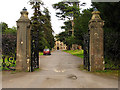
Entrance to Grittleton School
The entrance to this school is in the north eastern corner of the square.
Image: © Pam Brophy
Taken: 23 Aug 2005
0.11 miles
6
Footpath near Grittleton
The footpath takes walkers across arable fields to join the Fosse Way.
Image: © Maigheach-gheal
Taken: 1 Jul 2009
0.11 miles
8
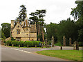
Gatehouse at Grittleton School
This square although all farmland, also has an intersection on the northern edge. This gatehouse to the school is on the south eastern corner of the intersection at gpr ST8584779965.
Image: © Pam Brophy
Taken: 23 Aug 2005
0.11 miles
9
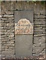
Old Milestone by The Street, Grittleton
Metal plate attached to stone post by the UC road, in parish of GRITTLETON (NORTH WILTSHIRE District), The Street; Grittleton; opposite Grittleton House School by "Masons", partially inset into wall, on North side of road. Erected by the Christian Malford to Shillingford turnpike trust in the 19th century.
Inscription reads:-
TO
Xn. MALFORD. 7
PUCKLECh. 11
BRISTOL. 18
Grade II listed.
List Entry Number: 1363847 https://historicengland.org.uk/listing/the-list/list-entry/1363847
Milestone Society National ID: WI_CMBR07.
Image: © M Faherty
Taken: 8 Jun 2008
0.11 miles
10
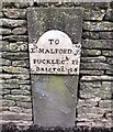
Old Milestone by The Street, Grittleton
Metal plate attached to stone post by the UC road, in parish of GRITTLETON (NORTH WILTSHIRE District), The Street; Grittleton; opposite Grittleton House School by "Masons", partially inset into wall, on North side of road. Erected by the Christian Malford to Shillingford turnpike trust in the 19th century.
Inscription reads:-
TO
Xn. MALFORD. 7
PUCKLECh. 11
BRISTOL. 18
Grade II listed.
List Entry Number: 1363847 https://historicengland.org.uk/listing/the-list/list-entry/1363847
Milestone Society National ID: WI_CMBR07
Image: © Simon Kosciow
Taken: 13 Jan 2019
0.11 miles