IMAGES TAKEN NEAR TO
Salisbury Close, CHIPPENHAM, SN14 0QX
Introduction
This page details the photographs taken nearby to Salisbury Close, SN14 0QX by members of the Geograph project.
The Geograph project started in 2005 with the aim of publishing, organising and preserving representative images for every square kilometre of Great Britain, Ireland and the Isle of Man.

There are currently over 7.5m images from over14,400 individuals and you can help contribute to the project by visiting https://www.geograph.org.uk
Image Map (Loading...)


Getting Data...Please wait
Leaflet Map data © OpenStreetMap
Images are licensed for reuse under creativecommons.org/licenses/by-sa/2.0
Notes
- Clicking on the map will re-center to the selected point.
- The higher the marker number, the further away the image location is from the centre of the postcode.
Image Listing (3 Images Found)
Images are licensed for reuse under creativecommons.org/licenses/by-sa/2.0
Image
Details
Distance
1
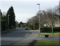
2009 : Queens' Crescent, Chippenham
That is how it is spelled on the sign, with the apostrophe after the s.
Image: © Maurice Pullin
Taken: 16 Feb 2009
0.17 miles
2
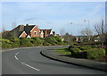
2009 : Sandown Drive, Chippenham
Here is evidence of improvement in modern housing estates. More thought is being given to their layout.
Image: © Maurice Pullin
Taken: 16 Feb 2009
0.19 miles
3
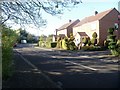
Sandown Drive
There is some nice topiary in this image of houses in Sandown Drive.
Image: © Michael Dibb
Taken: 22 Apr 2017
0.21 miles