IMAGES TAKEN NEAR TO
Barken Road, CHIPPENHAM, SN14 0JY
Introduction
This page details the photographs taken nearby to Barken Road, SN14 0JY by members of the Geograph project.
The Geograph project started in 2005 with the aim of publishing, organising and preserving representative images for every square kilometre of Great Britain, Ireland and the Isle of Man.

There are currently over 7.5m images from over14,400 individuals and you can help contribute to the project by visiting https://www.geograph.org.uk
Image Map (Loading...)


Getting Data...Please wait
Leaflet Map data © OpenStreetMap
Images are licensed for reuse under creativecommons.org/licenses/by-sa/2.0
Notes
- Clicking on the map will re-center to the selected point.
- The higher the marker number, the further away the image location is from the centre of the postcode.
Image Listing (12 Images Found)
Images are licensed for reuse under creativecommons.org/licenses/by-sa/2.0
Image
Details
Distance
1
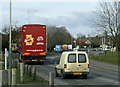
2009 : An unusual shade of green
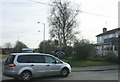
Traffic on Hungerdown Lane heading north.
That white(?) van is even dirtier than mine.
Image: © Maurice Pullin
Taken: 16 Feb 2009
0.11 miles
3
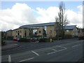
Chippenham, Hathaway Medical Centre
On Marshfield Road, at the junction with Middlefield Road. http://www.hathawaysurgery.co.uk/asp/mContent.asp?pID=389
Image: © Mike Faherty
Taken: 7 Apr 2010
0.15 miles
4
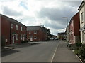
Chippenham, Middlefield Road
In the foreground, modern housing; older, farther South.
Image: © Mike Faherty
Taken: 7 Apr 2010
0.15 miles
5
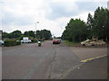
Bumpers Farm industrial estate
A view looking south along the main spine road on the Bumper Farm industrial estate.
Image: © Phil Williams
Taken: 27 Jun 2006
0.16 miles
6
Bumpers Farm industrial estate
A view looking north along the main spine road towards the entrance to Bumpers Farm industrial estate.
Image: © Phil Williams
Taken: 27 Jun 2006
0.16 miles
7
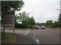
Brand new Lidl store on Hungerdown Lane, Chippenham
It opened on February the 14th 2019. The map shows a school occupied the site previously.
Image: © David Howard
Taken: 1 Jun 2019
0.16 miles
8
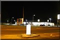
2009 : The Kingfisher, Hungerdown Lane
Image: © Maurice Pullin
Taken: 16 Feb 2009
0.17 miles
9
Old Milestone by the A420, Bristol Road, Chippenham
Metal plate attached to stone post by the A420, in parish of CHIPPENHAM WITHOUT (NORTH WILTSHIRE District), Bristol Road, 105m North West of junction with Old Hardenhuish Lane and tollhouse, deep in hedge between path and wooden fence, on North side of road. Marshfield iron plate, erected by the Chippenham turnpike trust in the 19th century.
Inscription reads:-
8 MILES
TO
(MARSHFIELD)
(1 MILE)
(TO)
(CHIPPENHAM)
Grade II listed. List Entry Number: 1022902
https://historicengland.org.uk/listing/the-list/list-entry/1022902
Milestone Society National ID: WI_CPMF01.
Image: © A Rosevear
Taken: 23 Sep 2003
0.20 miles
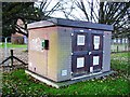
10
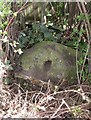
Inverted benchmark
It's not terribly common but sometimes the arrows are above the datum line. However, it may be that the mark was originally positioned elsewhere at Folly Gate and the stonework reused after rebuilding. Historic references appear to indicate the mark at this location since the late 1880s. See http://www.bench-marks.org.uk/bm41652 for the Benchmark Database, or Image] for a look at the old turnpike tollhouse.
Image: © Neil Owen
Taken: 29 Feb 2012
0.20 miles