IMAGES TAKEN NEAR TO
Hungerdown Lane, CHIPPENHAM, SN14 0BD
Introduction
This page details the photographs taken nearby to Hungerdown Lane, SN14 0BD by members of the Geograph project.
The Geograph project started in 2005 with the aim of publishing, organising and preserving representative images for every square kilometre of Great Britain, Ireland and the Isle of Man.

There are currently over 7.5m images from over14,400 individuals and you can help contribute to the project by visiting https://www.geograph.org.uk
Image Map
Images are licensed for reuse under creativecommons.org/licenses/by-sa/2.0
Notes
- Clicking on the map will re-center to the selected point.
- The higher the marker number, the further away the image location is from the centre of the postcode.
Image Listing (4 Images Found)
Images are licensed for reuse under creativecommons.org/licenses/by-sa/2.0
Image
Details
Distance
1
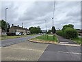
St. Peters, Frogwell
A view looking north across Frogwell to the parish church of St. Peter.
Image: © Phil Williams
Taken: 27 Jun 2006
0.06 miles
2
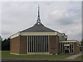
2009 : The Kingfisher, Hungerdown Lane
Image: © Maurice Pullin
Taken: 16 Feb 2009
0.19 miles
3
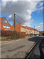
Sheldon Road
Sheldon Road, junction with Stonelea Close in Chippenham.
Image: © Wayland Smith
Taken: 8 Mar 2020
0.20 miles