IMAGES TAKEN NEAR TO
The Nurseries, SWINDON, SN1 3QD
Introduction
This page details the photographs taken nearby to The Nurseries, SN1 3QD by members of the Geograph project.
The Geograph project started in 2005 with the aim of publishing, organising and preserving representative images for every square kilometre of Great Britain, Ireland and the Isle of Man.

There are currently over 7.5m images from over14,400 individuals and you can help contribute to the project by visiting https://www.geograph.org.uk
Image Map
Images are licensed for reuse under creativecommons.org/licenses/by-sa/2.0
Notes
- Clicking on the map will re-center to the selected point.
- The higher the marker number, the further away the image location is from the centre of the postcode.
Image Listing (106 Images Found)
Images are licensed for reuse under creativecommons.org/licenses/by-sa/2.0
Image
Details
Distance
1
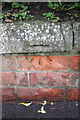
Benchmark on roadside wall of #61 Kingshill Road
Ordnance Survey cut mark benchmark described on the Bench Mark Database at http://www.bench-marks.org.uk/bm40450
Image: © Roger Templeman
Taken: 5 Jan 2012
0.05 miles
2
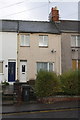
#61 Kingshill Road
There is an OS benchmark Image on the wall in front of the house below the dip in the hedge
Image: © Roger Templeman
Taken: 5 Jan 2012
0.05 miles
3
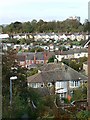
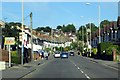
Houses between New Town and Old Town, Swindon
The original Swindon was a small market town on top of a hill and might have remained so had not Brunel decided to build a major factory for the Great Western Railway in the mid 19th century. Thus was born Swindon New Town. As more houses were built in the Victorian era and later, the two areas merged. The term 'New Town' is now little-heard; in contrast 'Old Town' is in common currency to distinguish the pre-railway development from the rest of the town. The houses nearest the viewpoint are in Bowood Road, a between-the-wars development. The furthest houses are in Clifton Street and date from the late 19th century. These are on the northern edge of this square. The modern high-rise building on the right skyline is the David Murray John Tower which is in Image
Image: © Brian Robert Marshall
Taken: 29 Oct 2007
0.07 miles
4
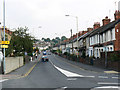
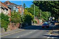
Kingshill Road, Swindon
Kingshill Road was and remains the main route into Old Town from the west. The houses along it are late Victorian or Edwardian. The yellow signs at the left indicate the route for the Wichelstowe development Image
Image: © Brian Robert Marshall
Taken: 19 Sep 2009
0.07 miles
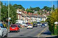
6
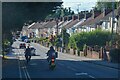
Swindon : Kingshill Road A4289
Looking along Kingshill Road.
Image: © Lewis Clarke
Taken: 14 Jul 2022
0.08 miles
7
Swindon : Kingshill Road A4289
Looking down the hill.
Image: © Lewis Clarke
Taken: 14 Jul 2022
0.09 miles
8
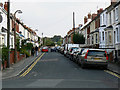
Exmouth Street, Swindon
The street is not quite a cul-de-sac as it is possible to drive beyond the end of the street along alleys to Kingshill Road. As this is not far from the town centre parking can be problematic for residents and on-street parking is essentially residents-only.
Image: © Brian Robert Marshall
Taken: 19 Sep 2009
0.09 miles
10
Swindon : Kingshill Road A4289
Looking along Kingshill Road.
Image: © Lewis Clarke
Taken: 14 Jul 2022
0.09 miles