IMAGES TAKEN NEAR TO
Exmouth Street, SWINDON, SN1 3PU
Introduction
This page details the photographs taken nearby to Exmouth Street, SN1 3PU by members of the Geograph project.
The Geograph project started in 2005 with the aim of publishing, organising and preserving representative images for every square kilometre of Great Britain, Ireland and the Isle of Man.

There are currently over 7.5m images from over14,400 individuals and you can help contribute to the project by visiting https://www.geograph.org.uk
Image Map
Images are licensed for reuse under creativecommons.org/licenses/by-sa/2.0
Notes
- Clicking on the map will re-center to the selected point.
- The higher the marker number, the further away the image location is from the centre of the postcode.
Image Listing (105 Images Found)
Images are licensed for reuse under creativecommons.org/licenses/by-sa/2.0
Image
Details
Distance
1
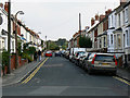
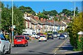
Exmouth Street, Swindon
The street is not quite a cul-de-sac as it is possible to drive beyond the end of the street along alleys to Kingshill Road. As this is not far from the town centre parking can be problematic for residents and on-street parking is essentially residents-only.
Image: © Brian Robert Marshall
Taken: 19 Sep 2009
0.02 miles
2
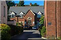
Swindon : Kingshill Court
Looking to Kingshill Court off Kingshill Road.
Image: © Lewis Clarke
Taken: 14 Jul 2022
0.04 miles
4
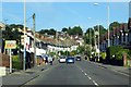
Kingshill Road, Swindon
Kingshill Road was and remains the main route into Old Town from the west. The houses along it are late Victorian or Edwardian. The yellow signs at the left indicate the route for the Wichelstowe development Image
Image: © Brian Robert Marshall
Taken: 19 Sep 2009
0.06 miles
5
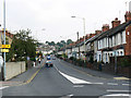
Swindon : Kingshill Road A4289
Looking along Kingshill Road.
Image: © Lewis Clarke
Taken: 14 Jul 2022
0.06 miles
6
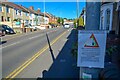
Swindon : Kingshill Road A4289
A sign says that speeding and this road could lead to health and mortality.
Image: © Lewis Clarke
Taken: 14 Jul 2022
0.06 miles
7
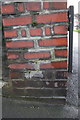
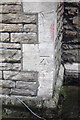
Damaged benchmark on wall pier of #169 Kingshill Road
The datum cut of this Ordnance Survey cut mark benchmark (which is described on the Bench Mark Database at http://www.bench-marks.org.uk/bm25592 ) is probably in its original position, but the right hand arrow cut can be seen at the left end of the left hand brick in the course below. The left hand arrow cut is on the right hand brick which has also been inverted.
Image: © Roger Templeman
Taken: 5 Jan 2012
0.07 miles
8
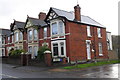
#169 Kingshill Road at junction with Hillside Avenue
There is a damaged OS benchmark Image on the corner wall pier (left of the road name sign)
Image: © Roger Templeman
Taken: 5 Jan 2012
0.07 miles
9
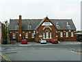
Former Clifton Street Schools, Radnor Street, Swindon
This fine Victorian redbrick school building has another life now as the offices of SSSL Ltd (Swindon Silicon Systems Limited) a hi-tech company. To quote from their website:
"Swindon Silicon Systems Limited is an innovative fabless semiconductor company that designs, develops and supplies highly integrated, performance driven, affordable, Custom Mixed Signal ASIC's and specialises in sensor interfaces for the Automotive and Industrial sectors."
Image: © Brian Robert Marshall
Taken: 19 Sep 2009
0.07 miles
10
Benchmark on #61 Radnor Street
Ordnance Survey cut mark benchmark described on the Bench Mark Database at http://www.bench-marks.org.uk/bm25589
Image: © Roger Templeman
Taken: 5 Jan 2012
0.07 miles