IMAGES TAKEN NEAR TO
Belgrave Street, SWINDON, SN1 3HR
Introduction
This page details the photographs taken nearby to Belgrave Street, SN1 3HR by members of the Geograph project.
The Geograph project started in 2005 with the aim of publishing, organising and preserving representative images for every square kilometre of Great Britain, Ireland and the Isle of Man.

There are currently over 7.5m images from over14,400 individuals and you can help contribute to the project by visiting https://www.geograph.org.uk
Image Map
Images are licensed for reuse under creativecommons.org/licenses/by-sa/2.0
Notes
- Clicking on the map will re-center to the selected point.
- The higher the marker number, the further away the image location is from the centre of the postcode.
Image Listing (299 Images Found)
Images are licensed for reuse under creativecommons.org/licenses/by-sa/2.0
Image
Details
Distance
1
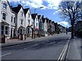
Victoria Road, Swindon
This street links Swindon's 'Old town', at the top of the hill, with the 'New town', which grew rapidly, around the canals and railway works, in the 19th century.
Image: © Roger Cornfoot
Taken: 13 Mar 2007
0.03 miles
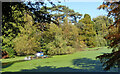
2
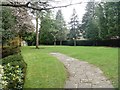
Queen's Park [4]
The grassy western edge of the park.
Queen's Park covers 12 acres with the large lake being some 2 acres. Once a derelict clay pit belonging to a local builder and brick maker Thomas Turner the park was laid out in an informal style in the 1950s and 1960s. The park is on the Register of Historic Parks and Gardens and there is much history and detail at: https://www.historicengland.org.uk/listing/the-list/list-entry/1001549
Image: © Michael Dibb
Taken: 28 Mar 2017
0.03 miles
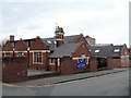
3
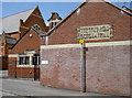
The school and hall
Holy Rood school and hall, from Durham Street. The inscription on the far wall is 'in hoc signo vinces' - by this sign you will conquer.
Image: © Neil Owen
Taken: 10 Jun 2014
0.04 miles
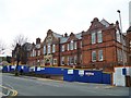
4
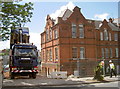
Time for a change
Swindon's old technical college is to be retained whilst all the old post-war college blocks are gone. After well over a century of education, the brick school is to be converted into office space. See Image] for more of the development.
Image: © Neil Owen
Taken: 10 Jun 2014
0.05 miles
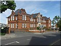
5
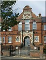
The former Technical School, Victoria Road, Swindon
The central bay of this fine building, now converted to apartments. The street wall and gateway are included in the Grade II Listing.
Image: © Alan Murray-Rust
Taken: 15 Jul 2022
0.05 miles
6
Former technical school
This wonderful Flemish-Baroque style building dates from 1895. The building is in the process of being converted into apartments. The building and front wall and gates are all listed, grade II, and there is much history and detail at: https://www.historicengland.org.uk/listing/the-list/list-entry/1418756
Image: © Michael Dibb
Taken: 28 Mar 2017
0.05 miles
7
Holy Rood school
The primary school is adjacent to the church of the same name.
Image: © Michael Dibb
Taken: 28 Mar 2017
0.05 miles
8
Clearing the Weed
Another picture at the weed infested pond in Queens Park.
A dredger is trying to scoop some of it up.
Image: © Des Blenkinsopp
Taken: 10 Oct 2022
0.06 miles
9
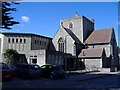
Holy Rood church, Swindon
A catholic church and primary school, viewed from Durham Street.
Image: © Roger Cornfoot
Taken: 13 Mar 2007
0.06 miles
10
Former Technical School, Victoria Road
Closed in 2006, subsequently Listed Grade II and finally refurbished as apartments.
Image: © Alan Murray-Rust
Taken: 15 Jul 2022
0.06 miles