IMAGES TAKEN NEAR TO
Belle Vue Road, SWINDON, SN1 3HQ
Introduction
This page details the photographs taken nearby to Belle Vue Road, SN1 3HQ by members of the Geograph project.
The Geograph project started in 2005 with the aim of publishing, organising and preserving representative images for every square kilometre of Great Britain, Ireland and the Isle of Man.

There are currently over 7.5m images from over14,400 individuals and you can help contribute to the project by visiting https://www.geograph.org.uk
Image Map
Images are licensed for reuse under creativecommons.org/licenses/by-sa/2.0
Notes
- Clicking on the map will re-center to the selected point.
- The higher the marker number, the further away the image location is from the centre of the postcode.
Image Listing (289 Images Found)
Images are licensed for reuse under creativecommons.org/licenses/by-sa/2.0
Image
Details
Distance
1
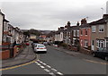
Belle Vue Road, Swindon
Looking NNE from the corner of Union Row.
Image: © Jaggery
Taken: 14 Apr 2013
0.02 miles
2
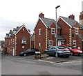
Little London, Swindon
Recently-built housing in the Old Town area of Swindon.
Image: © Jaggery
Taken: 14 Apr 2013
0.02 miles
3
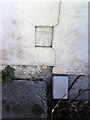
Benchmark on #18 Cricklade Street
Ordnance Survey cut mark benchmark described on the Bench Mark Database at http://www.bench-marks.org.uk/bm37350
Image: © Roger Templeman
Taken: 18 Mar 2011
0.02 miles
4
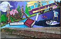
Mural, Belle Vue Road, Swindon
Swindon has quite a tradition for murals. This is one of the latest. Created by local artist Sarah Harris, the work shows from left, Christ Church, a mid-Victorian Gothic revival church, pigs being taken up the hill to the local livestock market that served the local community until the late 20th century, the Domesday Book in which Swindon gets a mention, the tram network that served Swindon into the inter-war years, and the legend of the Moonrakers (more strictly a Wiltshire rather than Swindon myth).
Image: © Brian Robert Marshall
Taken: 19 Nov 2021
0.03 miles
5
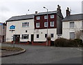
R.A.F.A Swindon branch
The Royal Air Forces Association Swindon branch is in Belle Vue Road.
Image: © Jaggery
Taken: 14 Apr 2013
0.03 miles
6
The R.A.F.A. branch
Swindon's branch of the Association in Belle Vue Road.
Image: © Neil Owen
Taken: 10 Jun 2014
0.03 miles
7
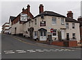
Longs Lounge, Swindon
On the corner of Union Row and Belle Vue Road, Longs Lounge is part of Longs Bar, available for private hire.
Image: © Jaggery
Taken: 14 Apr 2013
0.03 miles
8
Cricklade Street, Swindon
Looking towards Drove Road past the left turn for Church Lane.
Image: © Jaggery
Taken: 14 Apr 2013
0.03 miles
9
A view down Little London, Swindon
Little London is now an unremarkable little backstreet just east of Albert Street Image but in its day the Albert Street/Little London area was a red light district and the haunt of the 'lowest labourers' where it was said that 'almost any vice might be witnessed or indulged in'. Source: 'Swindon. An Illustrated History' Mark Child, Breedon Books, 2002. The tall chimney in the background marks the location of BMW's MINI panel plant at SU167863, 2.77 kilometres north.
Image: © Brian Robert Marshall
Taken: 16 Dec 2007
0.03 miles
10
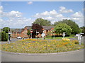
Wild at Bellevue Road
The simple roundabout at Bellevue Road has benefited from a generous helping of wild flowers. See Image] for a closer look. Also see Image] for a look at the state of it by September.
Image: © Neil Owen
Taken: 10 Jun 2014
0.04 miles