IMAGES TAKEN NEAR TO
Vicarage View, Little London, SWINDON, SN1 3FL
Introduction
This page details the photographs taken nearby to Vicarage View, Little London, SN1 3FL by members of the Geograph project.
The Geograph project started in 2005 with the aim of publishing, organising and preserving representative images for every square kilometre of Great Britain, Ireland and the Isle of Man.

There are currently over 7.5m images from over14,400 individuals and you can help contribute to the project by visiting https://www.geograph.org.uk
Image Map
Images are licensed for reuse under creativecommons.org/licenses/by-sa/2.0
Notes
- Clicking on the map will re-center to the selected point.
- The higher the marker number, the further away the image location is from the centre of the postcode.
Image Listing (287 Images Found)
Images are licensed for reuse under creativecommons.org/licenses/by-sa/2.0
Image
Details
Distance
1
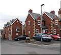
Little London, Swindon
Recently-built housing in the Old Town area of Swindon.
Image: © Jaggery
Taken: 14 Apr 2013
0.01 miles
2
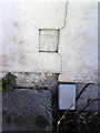
Benchmark on #18 Cricklade Street
Ordnance Survey cut mark benchmark described on the Bench Mark Database at http://www.bench-marks.org.uk/bm37350
Image: © Roger Templeman
Taken: 18 Mar 2011
0.02 miles
3
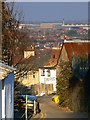
A view down Little London, Swindon
Little London is now an unremarkable little backstreet just east of Albert Street Image but in its day the Albert Street/Little London area was a red light district and the haunt of the 'lowest labourers' where it was said that 'almost any vice might be witnessed or indulged in'. Source: 'Swindon. An Illustrated History' Mark Child, Breedon Books, 2002. The tall chimney in the background marks the location of BMW's MINI panel plant at SU167863, 2.77 kilometres north.
Image: © Brian Robert Marshall
Taken: 16 Dec 2007
0.02 miles
4
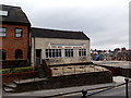
Pope Bros office and yard in Swindon
Building contractors' premises viewed across Cricklade Street looking towards the corner of Church Lane.
Image: © Jaggery
Taken: 14 Apr 2013
0.03 miles
5
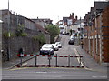
Church Road is closed
The barriers look fairly temporary but the double yellow lines imply a more permanent solution.
Image: © Neil Owen
Taken: 10 Jun 2014
0.03 miles
6
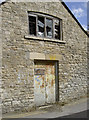
Mission over
A forlorn and derelict appearing building on Church Road. Old maps indicate it was a former mission hall.
Image: © Neil Owen
Taken: 10 Jun 2014
0.03 miles
7
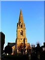
Christ Church, Cricklade Street, Swindon (1)
A view of the Anglican church facing east. It stands on a prominent position in Swindon's Old Town and can be seen from miles around. It was built in 1851 to a design by Sir George Gilbert Scott.
Image: © Brian Robert Marshall
Taken: 6 Feb 2007
0.04 miles
8
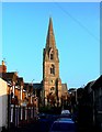
Christ Church, Cricklade Street, Swindon (2)
This view shows the church from a point in Church Road facing east towards Cricklade Street.
Image: © Brian Robert Marshall
Taken: 6 Feb 2007
0.04 miles
9

Christ Church, Cricklade Street, Swindon (3)
Looking to the top of the spire.
Image: © Brian Robert Marshall
Taken: 6 Feb 2007
0.04 miles
10
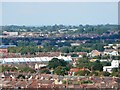
View north from Christ Church belfry, Cricklade Street, Swindon (2)
This telephoto image was taken on a day when the church Image was holding a fete in the grounds and the belfry was open. The white building in the left centre was Wickes DIY store at SU158855. Wickes have recently opened a new store on another site north of this location and this one is now vacant. The building below the left skyline is Kingsdown School at SU168881. The pylon on the horizon is probably at SU167888.
Image: © Brian Robert Marshall
Taken: 23 Sep 2006
0.04 miles