IMAGES TAKEN NEAR TO
Victoria Road, SWINDON, SN1 3DE
Introduction
This page details the photographs taken nearby to Victoria Road, SN1 3DE by members of the Geograph project.
The Geograph project started in 2005 with the aim of publishing, organising and preserving representative images for every square kilometre of Great Britain, Ireland and the Isle of Man.

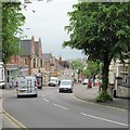
There are currently over 7.5m images from over14,400 individuals and you can help contribute to the project by visiting https://www.geograph.org.uk
Image Map
Images are licensed for reuse under creativecommons.org/licenses/by-sa/2.0
Notes
- Clicking on the map will re-center to the selected point.
- The higher the marker number, the further away the image location is from the centre of the postcode.
Image Listing (319 Images Found)
Images are licensed for reuse under creativecommons.org/licenses/by-sa/2.0
Image
Details
Distance
1
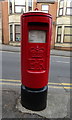
Elizabeth II postbox on Victoria Road, Swindon
Postbox No. SN1 98.
See Image] for context.
Image: © JThomas
Taken: 13 Jul 2019
0.01 miles
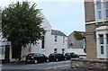
3
Victoria Road, Swindon
Showing position of Postbox No. SN1 98.
See Image] for postbox.
Image: © JThomas
Taken: 13 Jul 2019
0.02 miles
4
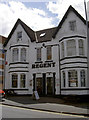
The Regent
This hotel, which is not as old as you might think (dating from the early twentieth century) regularly hosts musical evenings.
Image: © Neil Owen
Taken: 10 Jun 2014
0.02 miles
5
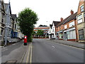
Victoria Road
One of the three major roads that link the old and new towns of Swindon, the others being Drove Road and Kingshill Road. The name suggests a late 19th century development as the then two separate communities at the top and bottom of the hill became linked, actually becoming the Borough of Swindon in November 1900. Before the construction of Victoria Road, the main link was via a country lane, Eastcott Hill, some 300m to the west. The photographer still remembers the days when he could cycle up this hill at a fair speed on his 10 speed racer [a very long time ago].
Image: © Gordon Hatton
Taken: 23 May 2017
0.03 miles
6
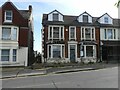
Oxford House, Victoria Road, Swindon
Once an attractive villa-style house; will it ever find someone willing to return it to condition or will it continue to decay?
Image: © Alan Murray-Rust
Taken: 15 Jul 2022
0.06 miles
7
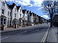
Victoria Road, Swindon
This street links Swindon's 'Old town', at the top of the hill, with the 'New town', which grew rapidly, around the canals and railway works, in the 19th century.
Image: © Roger Cornfoot
Taken: 13 Mar 2007
0.06 miles
8
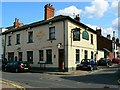
The Castle Inn, North Street, Swindon
A typical Old Town pub. The photographer spent many a happy hour in his youth here when there was a popular folk music club every Sunday evening. Paul Simon performed here in 1965 as did Julie Felix, Al Stewart and many others of varying degrees of fame.
Image: © Brian Robert Marshall
Taken: 28 Jul 2007
0.07 miles
9
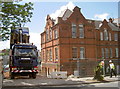
Time for a change
Swindon's old technical college is to be retained whilst all the old post-war college blocks are gone. After well over a century of education, the brick school is to be converted into office space. See Image] for more of the development.
Image: © Neil Owen
Taken: 10 Jun 2014
0.08 miles
10
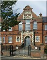
The former Technical School, Victoria Road, Swindon
The central bay of this fine building, now converted to apartments. The street wall and gateway are included in the Grade II Listing.
Image: © Alan Murray-Rust
Taken: 15 Jul 2022
0.09 miles